

Körtúra a Psunj hegységben
A cycling route starting in Cernik, Brod-Posavina County, Croatia.
Overview
About this route
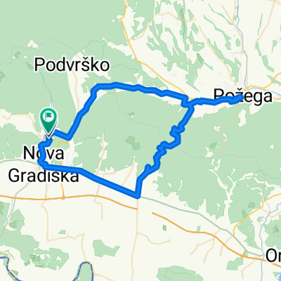
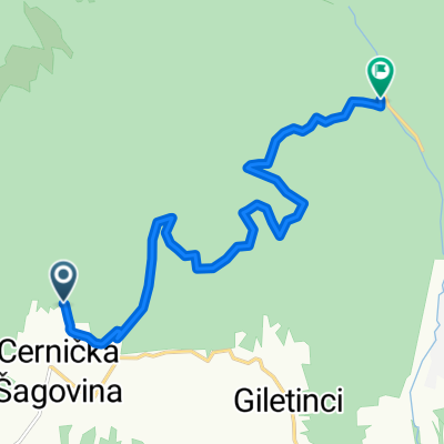
A circular tour starting from Strmacbòl to the highest peak of Psunj, the 985-meter-high Brezovo polje. The second leg of the tour follows the ridge between Dobra Voda – Crna mlaka – Žakina livada, then descends to the village of Cernička Šagovina at the foot of the mountain. The final stage once again follows the mountainside to the village of Šumetlica, then on a paved road back to Strmac.
- -:--
- Duration
- 43.5 km
- Distance
- 1,321 m
- Ascent
- 1,319 m
- Descent
- ---
- Avg. speed
- 990 m
- Max. altitude

Route photos

Route quality
Waytypes & surfaces along the route
Waytypes
Track
34.8 km
(80 %)
Quiet road
2.2 km
(5 %)
Undefined
6.5 km
(15 %)
Surfaces
Paved
4.8 km
(11 %)
Unpaved
31.3 km
(72 %)
Gravel
31.3 km
(72 %)
Asphalt
4.8 km
(11 %)
Undefined
7.4 km
(17 %)
Continue with Bikemap
Use, edit, or download this cycling route
You would like to ride Körtúra a Psunj hegységben or customize it for your own trip? Here is what you can do with this Bikemap route:
Free features
- Save this route as favorite or in collections
- Copy & plan your own version of this route
- Sync your route with Garmin or Wahoo
Premium features
Free trial for 3 days, or one-time payment. More about Bikemap Premium.
- Navigate this route on iOS & Android
- Export a GPX / KML file of this route
- Create your custom printout (try it for free)
- Download this route for offline navigation
Discover more Premium features.
Get Bikemap PremiumFrom our community
Other popular routes starting in Cernik
 Körtúra a Psunj hegységben
- Distance
- 43.5 km
- Ascent
- 1,321 m
- Descent
- 1,319 m
- Location
- Cernik, Brod-Posavina County, Croatia
 107. Strmac - Podvrško
- Distance
- 9 km
- Ascent
- 237 m
- Descent
- 274 m
- Location
- Cernik, Brod-Posavina County, Croatia
 Cernik (samostan) - Zapolje (župa)
- Distance
- 9.7 km
- Ascent
- 26 m
- Descent
- 64 m
- Location
- Cernik, Brod-Posavina County, Croatia
 Uphill utrka
- Distance
- 10.4 km
- Ascent
- 677 m
- Descent
- 89 m
- Location
- Cernik, Brod-Posavina County, Croatia
 Cernik - Brezovo Polje
- Distance
- 44.5 km
- Ascent
- 1,393 m
- Descent
- 1,389 m
- Location
- Cernik, Brod-Posavina County, Croatia
 112. Strmac - Velik Gaj - Golobrdac - Podvrško
- Distance
- 18.1 km
- Ascent
- 472 m
- Descent
- 486 m
- Location
- Cernik, Brod-Posavina County, Croatia
 maksim test
- Distance
- 70.5 km
- Ascent
- 650 m
- Descent
- 699 m
- Location
- Cernik, Brod-Posavina County, Croatia
 Sagovina_drugi dio
- Distance
- 10.7 km
- Ascent
- 338 m
- Descent
- 316 m
- Location
- Cernik, Brod-Posavina County, Croatia
Open it in the app