

Saverne - Etival (gravel)
A cycling route starting in Saverne, Grand Est, France.
Overview
About this route
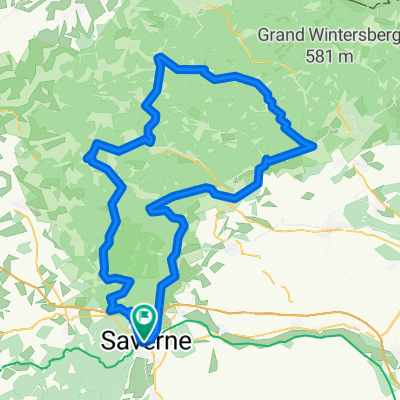
This gravel route connects Saverne (located on the SNCF Nancy - Strasbourg line) and Étival (located on the SNCF Nancy - St. Dié line). From Saverne, you first follow the Marne-Rhine canal westwards (towards Phalsbourg) for a few kilometers. At Stambach, take a paved forest road south and follow it until you reach the D980 below La Hoube. Follow this road uphill to the village, then shortly after the village turn right onto a gravel road (beautiful view of the Dabo). Follow the route passing over the Col de la Schleif, with very varied landscapes. Note that the GPX track follows a hiking trail below the Grossmann: this section is actually impassable, so it's better to stay on the forest road to reach the Maison Forestière de Grossmann. From there, a final climb on a gravel track leads to the D145 and then the Col du Donon. At the junction, turn right, then left after the grass (national necropolis) onto the paved forest road of the Col de Prayé. After the pass, continue following the road descending the Rabodeau valley to reach Moussey, then continue to La Petite Raon and Senones. From Senones, a bike path leads to the destination at Étival.
- -:--
- Duration
- 81.7 km
- Distance
- 2,015 m
- Ascent
- 1,896 m
- Descent
- ---
- Avg. speed
- 894 m
- Max. altitude
Route photos
\"")
\"")
\"")
\"")
\"")
\"")
\"")
Route quality
Waytypes & surfaces along the route
Waytypes
Quiet road
32.7 km
(40 %)
Track
17.2 km
(21 %)
Surfaces
Paved
41.7 km
(51 %)
Unpaved
18 km
(22 %)
Asphalt
41.7 km
(51 %)
Unpaved (undefined)
9 km
(11 %)
Continue with Bikemap
Use, edit, or download this cycling route
You would like to ride Saverne - Etival (gravel) or customize it for your own trip? Here is what you can do with this Bikemap route:
Free features
- Save this route as favorite or in collections
- Copy & plan your own version of this route
- Split it into stages to create a multi-day tour
- Sync your route with Garmin or Wahoo
Premium features
Free trial for 3 days, or one-time payment. More about Bikemap Premium.
- Navigate this route on iOS & Android
- Export a GPX / KML file of this route
- Create your custom printout (try it for free)
- Download this route for offline navigation
Discover more Premium features.
Get Bikemap PremiumFrom our community
Other popular routes starting in Saverne
 Saverne - Etival (gravel)
- Distance
- 81.7 km
- Ascent
- 2,015 m
- Descent
- 1,896 m
- Location
- Saverne, Grand Est, France
 2018 Tour 2
- Distance
- 114 km
- Ascent
- 849 m
- Descent
- 849 m
- Location
- Saverne, Grand Est, France
 Saverne - Darmstadt
- Distance
- 290.6 km
- Ascent
- 97 m
- Descent
- 165 m
- Location
- Saverne, Grand Est, France
 La forêt de Saverne en vélo de route
- Distance
- 21.3 km
- Ascent
- 411 m
- Descent
- 411 m
- Location
- Saverne, Grand Est, France
 2ème étape Crête des Vosges
- Distance
- 127.9 km
- Ascent
- 2,107 m
- Descent
- 1,758 m
- Location
- Saverne, Grand Est, France
 Route Saverne - Plan Incline - Dabo
- Distance
- 60.9 km
- Ascent
- 726 m
- Descent
- 726 m
- Location
- Saverne, Grand Est, France
 Deutschland - Portugal (Berlin - Faro) FR 04 Savern - Obernai
- Distance
- 44.5 km
- Ascent
- 332 m
- Descent
- 352 m
- Location
- Saverne, Grand Est, France
 Saverne - St. Dié (gravel)
- Distance
- 94 km
- Ascent
- 2,652 m
- Descent
- 2,514 m
- Location
- Saverne, Grand Est, France
Open it in the app