

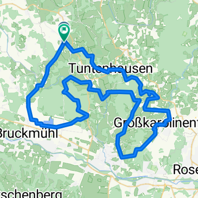
Gemeinderundweg Tuntenhausen - Gemeinderundweg Tuntenhausen
A cycling route starting in Tuntenhausen, Bavaria, Germany.
Overview
About this route
Beautiful circular route through the municipality of Tuntenhausen with a magnificent view of the Alpine range
- -:--
- Duration
- 37.6 km
- Distance
- 407 m
- Ascent
- 409 m
- Descent
- ---
- Avg. speed
- 571 m
- Max. altitude

Route quality
Waytypes & surfaces along the route
Waytypes
Quiet road
30.5 km
(81 %)
Road
2.6 km
(7 %)
Surfaces
Paved
32.7 km
(87 %)
Unpaved
3 km
(8 %)
Asphalt
32.7 km
(87 %)
Gravel
3 km
(8 %)
Undefined
1.9 km
(5 %)
Continue with Bikemap
Use, edit, or download this cycling route
You would like to ride Gemeinderundweg Tuntenhausen - Gemeinderundweg Tuntenhausen or customize it for your own trip? Here is what you can do with this Bikemap route:
Free features
- Save this route as favorite or in collections
- Copy & plan your own version of this route
- Sync your route with Garmin or Wahoo
Premium features
Free trial for 3 days, or one-time payment. More about Bikemap Premium.
- Navigate this route on iOS & Android
- Export a GPX / KML file of this route
- Create your custom printout (try it for free)
- Download this route for offline navigation
Discover more Premium features.
Get Bikemap PremiumFrom our community
Other popular routes starting in Tuntenhausen
 Tuntenhausen Wolfersberg Neuperlach
- Distance
- 41.8 km
- Ascent
- 355 m
- Descent
- 300 m
- Location
- Tuntenhausen, Bavaria, Germany
 Von Tuntenhausen nach München/Neuperlach
- Distance
- 42.5 km
- Ascent
- 363 m
- Descent
- 321 m
- Location
- Tuntenhausen, Bavaria, Germany
 Route von Antersberg 500, Tuntenhausen
- Distance
- 39.9 km
- Ascent
- 275 m
- Descent
- 237 m
- Location
- Tuntenhausen, Bavaria, Germany
 20.06.11 Frohnleichnamstour
- Distance
- 49.6 km
- Ascent
- 314 m
- Descent
- 303 m
- Location
- Tuntenhausen, Bavaria, Germany
 Um Biberg und Tuntenhausen
- Distance
- 59.1 km
- Ascent
- 220 m
- Descent
- 224 m
- Location
- Tuntenhausen, Bavaria, Germany
 Mangfalltal
- Distance
- 52.9 km
- Ascent
- 189 m
- Descent
- 194 m
- Location
- Tuntenhausen, Bavaria, Germany
 Gemeinderundweg Tuntenhausen - Gemeinderundweg Tuntenhausen
- Distance
- 37.6 km
- Ascent
- 407 m
- Descent
- 409 m
- Location
- Tuntenhausen, Bavaria, Germany
 Arbeit über Glonn und Siegertsbrunn nach Neuperlach
- Distance
- 41.2 km
- Ascent
- 280 m
- Descent
- 230 m
- Location
- Tuntenhausen, Bavaria, Germany
Open it in the app