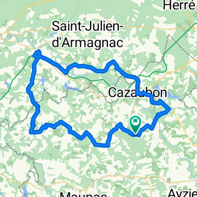
453 Route de St-Christau, Cazaubon nach 3 Place Porte Campet, Mont-de-Marsan
A cycling route starting in Cazaubon, Occitanie, France.
Overview
About this route
- 2 h 19 min
- Duration
- 45.2 km
- Distance
- 275 m
- Ascent
- 345 m
- Descent
- 19.5 km/h
- Avg. speed
- 142 m
- Max. altitude
Route quality
Waytypes & surfaces along the route
Waytypes
Road
13.6 km
(30 %)
Track
4.1 km
(9 %)
Surfaces
Paved
9.9 km
(22 %)
Unpaved
4.5 km
(10 %)
Asphalt
9.5 km
(21 %)
Gravel
4.1 km
(9 %)
Continue with Bikemap
Use, edit, or download this cycling route
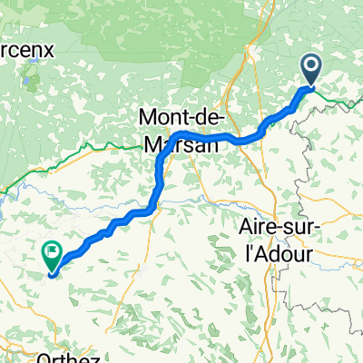
You would like to ride 453 Route de St-Christau, Cazaubon nach 3 Place Porte Campet, Mont-de-Marsan or customize it for your own trip? Here is what you can do with this Bikemap route:
Free features
- Save this route as favorite or in collections
- Copy & plan your own version of this route
- Sync your route with Garmin or Wahoo
Premium features
Free trial for 3 days, or one-time payment. More about Bikemap Premium.
- Navigate this route on iOS & Android
- Export a GPX / KML file of this route
- Create your custom printout (try it for free)
- Download this route for offline navigation
Discover more Premium features.
Get Bikemap PremiumFrom our community
Other popular routes starting in Cazaubon
LABASTIDE naar LAREE via Betbezer, Mauvezin en Monclar- Distance
- 16.5 km
- Ascent
- 137 m
- Descent
- 98 m
- Location
- Cazaubon, Occitanie, France
Cazaubon - Pomarez- Distance
- 75.7 km
- Ascent
- 638 m
- Descent
- 707 m
- Location
- Cazaubon, Occitanie, France
Deutschland - Portugal (Berlin - Faro) FR 30 Cazaubon - Mont-de-Marsan- Distance
- 42.9 km
- Ascent
- 259 m
- Descent
- 339 m
- Location
- Cazaubon, Occitanie, France
SENNE naar LABASTIDE via Soubére/Lannemagnan terug via Betbezer en Mauvezin- Distance
- 41 km
- Ascent
- 241 m
- Descent
- 242 m
- Location
- Cazaubon, Occitanie, France
Itinéraire reposant en Villeneuve-de-Marsan- Distance
- 14.9 km
- Ascent
- 132 m
- Descent
- 144 m
- Location
- Cazaubon, Occitanie, France
Lusolle: SOURCES DE MONCAUT- Distance
- 83.6 km
- Ascent
- 217 m
- Descent
- 217 m
- Location
- Cazaubon, Occitanie, France
2015 Ride Day 35 - Labastide d'Armagnac to Le Passage-d'Agen- Distance
- 85.5 km
- Ascent
- 507 m
- Descent
- 532 m
- Location
- Cazaubon, Occitanie, France
Eug-laberdolive- Distance
- 43.8 km
- Ascent
- 288 m
- Descent
- 320 m
- Location
- Cazaubon, Occitanie, France
Open it in the app

