

Radrunde um Oberstenfeld
A cycling route starting in Oberstenfeld, Baden-Wurttemberg, Germany.
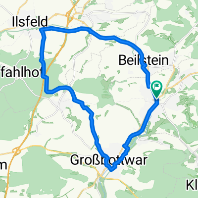
Overview
About this route
Bike loop around Oberstenfeld / Start: parking lot of the sports hall/multipurpose hall Gronau in Hermann-Helber-Straße in Oberstenfeld-Gronau or any stop of the Berg-und-Tal bus / Route length about 43 km, elevation gain about 650 m / Surface roughly half gravel and half asphalt / Net riding time (without breaks) about 3 hours.
- 4 h 40 min
- Duration
- 42.8 km
- Distance
- 831 m
- Ascent
- 830 m
- Descent
- 9.2 km/h
- Avg. speed
- 490 m
- Max. altitude
Route quality
Waytypes & surfaces along the route
Waytypes
Track
33 km
(77 %)
Quiet road
3.9 km
(9 %)
Surfaces
Paved
23.1 km
(54 %)
Unpaved
19.7 km
(46 %)
Asphalt
21 km
(49 %)
Gravel
15.4 km
(36 %)
Continue with Bikemap
Use, edit, or download this cycling route
You would like to ride Radrunde um Oberstenfeld or customize it for your own trip? Here is what you can do with this Bikemap route:
Free features
- Save this route as favorite or in collections
- Copy & plan your own version of this route
- Sync your route with Garmin or Wahoo
Premium features
Free trial for 3 days, or one-time payment. More about Bikemap Premium.
- Navigate this route on iOS & Android
- Export a GPX / KML file of this route
- Create your custom printout (try it for free)
- Download this route for offline navigation
Discover more Premium features.
Get Bikemap PremiumFrom our community
Other popular routes starting in Oberstenfeld
 Loewensteiner Berge
- Distance
- 61.5 km
- Ascent
- 905 m
- Descent
- 905 m
- Location
- Oberstenfeld, Baden-Wurttemberg, Germany
 Radrunde um Oberstenfeld
- Distance
- 42.8 km
- Ascent
- 831 m
- Descent
- 830 m
- Location
- Oberstenfeld, Baden-Wurttemberg, Germany
 Gronau roundtrip
- Distance
- 51.3 km
- Ascent
- 950 m
- Descent
- 950 m
- Location
- Oberstenfeld, Baden-Wurttemberg, Germany
 Rute mit anspruchsvoller Steigung und rasanter Abfahrt
- Distance
- 46.2 km
- Ascent
- 824 m
- Descent
- 811 m
- Location
- Oberstenfeld, Baden-Wurttemberg, Germany
 Oberstenfeld Sinzenburg
- Distance
- 23.2 km
- Ascent
- 400 m
- Descent
- 400 m
- Location
- Oberstenfeld, Baden-Wurttemberg, Germany
 Gronau - xxx - Gronau
- Distance
- 99.3 km
- Ascent
- 1,104 m
- Descent
- 1,103 m
- Location
- Oberstenfeld, Baden-Wurttemberg, Germany
 Ilsfeld - Wunnenstein - Großbottwar
- Distance
- 20.3 km
- Ascent
- 178 m
- Descent
- 178 m
- Location
- Oberstenfeld, Baden-Wurttemberg, Germany
 Bottwartal-Gronau-Neuwirtshaus-Forsthof-Steinheim
- Distance
- 35.9 km
- Ascent
- 268 m
- Descent
- 394 m
- Location
- Oberstenfeld, Baden-Wurttemberg, Germany
Open it in the app