

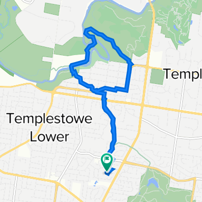
Templestowe College - Birrarung Marr
A cycling route starting in Templestowe Lower, Victoria, Australia.
Overview
About this route
VCAL WRS OHS Activity
- -:--
- Duration
- 28.5 km
- Distance
- 291 m
- Ascent
- 355 m
- Descent
- ---
- Avg. speed
- 92 m
- Max. altitude

Route quality
Waytypes & surfaces along the route
Waytypes
Cycleway
20.5 km
(72 %)
Quiet road
4 km
(14 %)
Surfaces
Paved
27.1 km
(95 %)
Asphalt
14.8 km
(52 %)
Concrete
6.8 km
(24 %)
Route highlights
Points of interest along the route
Point of interest after 2.3 km
Manningham Road Crossing - Use Footbridge
Point of interest after 4 km
First Rest Point - 5mins
Point of interest after 9.7 km
Rest Break - 5mins
Point of interest after 13.3 km
Rest Break - 15mins
Continue with Bikemap
Use, edit, or download this cycling route
You would like to ride Templestowe College - Birrarung Marr or customize it for your own trip? Here is what you can do with this Bikemap route:
Free features
- Save this route as favorite or in collections
- Copy & plan your own version of this route
- Sync your route with Garmin or Wahoo
Premium features
Free trial for 3 days, or one-time payment. More about Bikemap Premium.
- Navigate this route on iOS & Android
- Export a GPX / KML file of this route
- Create your custom printout (try it for free)
- Download this route for offline navigation
Discover more Premium features.
Get Bikemap PremiumFrom our community
Other popular routes starting in Templestowe Lower
 Balmoral Avenue 19, Templestowe Lower to Barkly Place 44, Heidelberg
- Distance
- 7.3 km
- Ascent
- 133 m
- Descent
- 130 m
- Location
- Templestowe Lower, Victoria, Australia
 Eltham Ride 2
- Distance
- 59.6 km
- Ascent
- 413 m
- Descent
- 424 m
- Location
- Templestowe Lower, Victoria, Australia
 22 Rosa Street, Templestowe Lower to 127-139 Tindals Road, Donvale
- Distance
- 15.5 km
- Ascent
- 152 m
- Descent
- 180 m
- Location
- Templestowe Lower, Victoria, Australia
 Templestowe College - Birrarung Marr
- Distance
- 28.5 km
- Ascent
- 291 m
- Descent
- 355 m
- Location
- Templestowe Lower, Victoria, Australia
 Home to Work
- Distance
- 19.8 km
- Ascent
- 227 m
- Descent
- 252 m
- Location
- Templestowe Lower, Victoria, Australia
 Alburnum Crescent 10, Templestowe Lower to Alburnum Crescent 10, Templestowe Lower
- Distance
- 8.9 km
- Ascent
- 116 m
- Descent
- 120 m
- Location
- Templestowe Lower, Victoria, Australia
 Manningham Road 188, Bulleen to Preston
- Distance
- 11.4 km
- Ascent
- 98 m
- Descent
- 110 m
- Location
- Templestowe Lower, Victoria, Australia
 304 High St, Templestowe Lower to 312–322 Middleborough Rd, Box Hill
- Distance
- 10.3 km
- Ascent
- 84 m
- Descent
- 93 m
- Location
- Templestowe Lower, Victoria, Australia
Open it in the app