

Segura XTRI Trailrun
A cycling route starting in Beas de Segura, Andalusia, Spain.
Overview
About this route
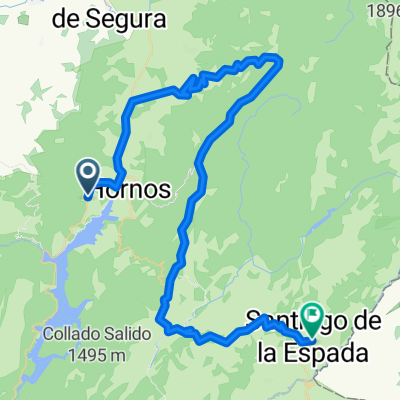
Segura XTRI Trail near El Tranco, Andalusia (Spain) by Rodri_poliniTrail distance: 24.23 mi. - 39 km.Elevation min: 661 meters max: 1478 metersUphill: 1728 meters down: 1190 metersType: One way Upload your trail to wikiloc.com →
- -:--
- Duration
- 38.2 km
- Distance
- 1,437 m
- Ascent
- 922 m
- Descent
- ---
- Avg. speed
- 1,478 m
- Max. altitude

Continue with Bikemap
Use, edit, or download this cycling route
You would like to ride Segura XTRI Trailrun or customize it for your own trip? Here is what you can do with this Bikemap route:
Free features
- Save this route as favorite or in collections
- Copy & plan your own version of this route
- Sync your route with Garmin or Wahoo
Premium features
Free trial for 3 days, or one-time payment. More about Bikemap Premium.
- Navigate this route on iOS & Android
- Export a GPX / KML file of this route
- Create your custom printout (try it for free)
- Download this route for offline navigation
Discover more Premium features.
Get Bikemap PremiumFrom our community
Other popular routes starting in Beas de Segura
 La Segureña
- Distance
- 124.2 km
- Ascent
- 1,553 m
- Descent
- 1,575 m
- Location
- Beas de Segura, Andalusia, Spain
 Cazorla (Collado Alto de los perros - La Traviesa)
- Distance
- 83.2 km
- Ascent
- 1,642 m
- Descent
- 1,635 m
- Location
- Beas de Segura, Andalusia, Spain
 Beas de Segura - La Cumbre - Despiernacaballos
- Distance
- 132.7 km
- Ascent
- 2,324 m
- Descent
- 2,329 m
- Location
- Beas de Segura, Andalusia, Spain
 Jaen 4: Beas de Segura - Aldeahermosa
- Distance
- 32.7 km
- Ascent
- 419 m
- Descent
- 353 m
- Location
- Beas de Segura, Andalusia, Spain
 Segura XTRI Trailrun
- Distance
- 38.2 km
- Ascent
- 1,437 m
- Descent
- 922 m
- Location
- Beas de Segura, Andalusia, Spain
 Hostal Losam to Santiago via Segura
- Distance
- 75.2 km
- Ascent
- 1,272 m
- Descent
- 715 m
- Location
- Beas de Segura, Andalusia, Spain
 Tranco Hoya Conejos Cerro Peguera Hoya Trevejiles
- Distance
- 37.8 km
- Ascent
- 989 m
- Descent
- 996 m
- Location
- Beas de Segura, Andalusia, Spain
 Segura XTRI Ciclismo
- Distance
- 186.5 km
- Ascent
- 7,323 m
- Descent
- 7,318 m
- Location
- Beas de Segura, Andalusia, Spain
Open it in the app