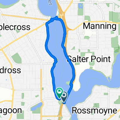
Christmas 22
A cycling route starting in Mount Pleasant, Western Australia, Australia.
Overview
About this route
- -:--
- Duration
- 24.2 km
- Distance
- 213 m
- Ascent
- 221 m
- Descent
- ---
- Avg. speed
- 62 m
- Avg. speed
Route highlights
Points of interest along the route
Point of interest after 1.7 km
37 Noalimba Rd Bateman
Point of interest after 5.9 km
43 Coope Ridge Winthrop
Point of interest after 7.3 km
5 Quell Dale
Point of interest after 10.5 km
58a Lamond St, Melville
Point of interest after 11.5 km
18 Young Street, Melville
Point of interest after 12.1 km
2C Gimber Street, Melville
Point of interest after 14.5 km
Cnr Moreing & Cawston, Attadale
Point of interest after 18.5 km
Canning Hwy Bicton, 2 houses
Point of interest after 20.7 km
72B McCallum Cr, Ardross
Continue with Bikemap
Use, edit, or download this cycling route
You would like to ride Christmas 22 or customize it for your own trip? Here is what you can do with this Bikemap route:
Free features
- Save this route as favorite or in collections
- Copy & plan your own version of this route
- Sync your route with Garmin or Wahoo
Premium features
Free trial for 3 days, or one-time payment. More about Bikemap Premium.
- Navigate this route on iOS & Android
- Export a GPX / KML file of this route
- Create your custom printout (try it for free)
- Download this route for offline navigation
Discover more Premium features.
Get Bikemap PremiumFrom our community
Other popular routes starting in Mount Pleasant
- crown route
- Distance
- 19.8 km
- Ascent
- 71 m
- Descent
- 71 m
- Location
- Mount Pleasant, Western Australia, Australia
- Christmas 22
- Distance
- 24.2 km
- Ascent
- 213 m
- Descent
- 221 m
- Location
- Mount Pleasant, Western Australia, Australia
- 80km - Mt Pleasant - Swan Valley (L.Albion) - Kings Park
- Distance
- 80.5 km
- Ascent
- 705 m
- Descent
- 705 m
- Location
- Mount Pleasant, Western Australia, Australia
- Lengthy bike tour through Bateman
- Distance
- 50.2 km
- Ascent
- 149 m
- Descent
- 148 m
- Location
- Mount Pleasant, Western Australia, Australia
- Kwinana Freeway, Bateman to 497 Wellington Street, Perth
- Distance
- 44.2 km
- Ascent
- 4 m
- Descent
- 12 m
- Location
- Mount Pleasant, Western Australia, Australia
- The Esplanade 241, Mount Pleasant to Rockett Way 11, Bull Creek
- Distance
- 3.9 km
- Ascent
- 49 m
- Descent
- 34 m
- Location
- Mount Pleasant, Western Australia, Australia
- Canning Diversion 1
- Distance
- 30.9 km
- Ascent
- 173 m
- Descent
- 173 m
- Location
- Mount Pleasant, Western Australia, Australia
- Perth Freemantle loop
- Distance
- 68.8 km
- Ascent
- 156 m
- Descent
- 163 m
- Location
- Mount Pleasant, Western Australia, Australia
Open it in the app