
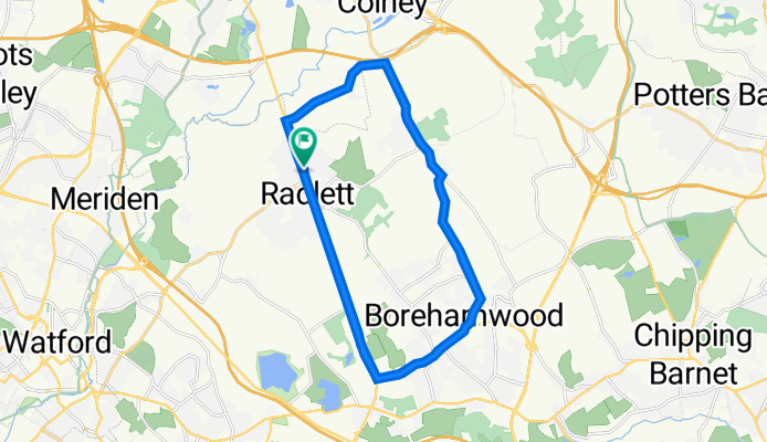
107A Watling St, Radlett to 107A Watling St, Radlett
A cycling route starting in Radlett, England, United Kingdom.
Overview
About this route
- 1 h 24 min
- Duration
- 34.2 km
- Distance
- 303 m
- Ascent
- 307 m
- Descent
- 24.5 km/h
- Avg. speed
- 135 m
- Max. altitude
Route quality
Waytypes & surfaces along the route
Waytypes
Busy road
30.4 km
(89 %)
Cycleway
1.7 km
(5 %)
Surfaces
Paved
17.6 km
(51 %)
Asphalt
17.2 km
(50 %)
Paved (undefined)
0.4 km
(1 %)
Continue with Bikemap
Use, edit, or download this cycling route
You would like to ride 107A Watling St, Radlett to 107A Watling St, Radlett or customize it for your own trip? Here is what you can do with this Bikemap route:
Free features
- Save this route as favorite or in collections
- Copy & plan your own version of this route
- Sync your route with Garmin or Wahoo
Premium features
Free trial for 3 days, or one-time payment. More about Bikemap Premium.
- Navigate this route on iOS & Android
- Export a GPX / KML file of this route
- Create your custom printout (try it for free)
- Download this route for offline navigation
Discover more Premium features.
Get Bikemap PremiumFrom our community
Other popular routes starting in Radlett
 longer loop
- Distance
- 76.4 km
- Ascent
- 439 m
- Descent
- 439 m
- Location
- Radlett, England, United Kingdom
 bricket wood loop towards StA
- Distance
- 9.4 km
- Ascent
- 37 m
- Descent
- 50 m
- Location
- Radlett, England, United Kingdom
 Radlett-Aldenham Park-Aldenham-Radlett-Shelley
- Distance
- 18.4 km
- Ascent
- 157 m
- Descent
- 107 m
- Location
- Radlett, England, United Kingdom
 High Wycombe
- Distance
- 87.6 km
- Ascent
- 397 m
- Descent
- 397 m
- Location
- Radlett, England, United Kingdom
 Radlett-Aldenham-Radlett Loop
- Distance
- 15.6 km
- Ascent
- 98 m
- Descent
- 95 m
- Location
- Radlett, England, United Kingdom
 1 Scrubbitts Park Road, Radlett to 1 Scrubbitts Park Road, Radlett
- Distance
- 18.2 km
- Ascent
- 165 m
- Descent
- 164 m
- Location
- Radlett, England, United Kingdom
 299 Watling St, Radlett to Headstone Lane, Harrow
- Distance
- 13.2 km
- Ascent
- 106 m
- Descent
- 134 m
- Location
- Radlett, England, United Kingdom
 Watford Road 51 to Gills Hill 17
- Distance
- 18.1 km
- Ascent
- 176 m
- Descent
- 179 m
- Location
- Radlett, England, United Kingdom
Open it in the app