
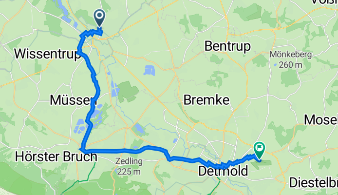
Auf der Lieth 14, Lage nach Im Fliegerhorst 13, Detmold
A cycling route starting in Lage, North Rhine-Westphalia, Germany.
Overview
About this route
- 1 h 16 min
- Duration
- 17.3 km
- Distance
- 153 m
- Ascent
- 80 m
- Descent
- 13.6 km/h
- Avg. speed
- 189 m
- Max. altitude

Route quality
Waytypes & surfaces along the route
Waytypes
Quiet road
7.9 km
(46 %)
Path
5.1 km
(30 %)
Surfaces
Paved
16.5 km
(96 %)
Unpaved
0.7 km
(4 %)
Asphalt
11.7 km
(68 %)
Paving stones
4.5 km
(26 %)
Continue with Bikemap
Use, edit, or download this cycling route
You would like to ride Auf der Lieth 14, Lage nach Im Fliegerhorst 13, Detmold or customize it for your own trip? Here is what you can do with this Bikemap route:
Free features
- Save this route as favorite or in collections
- Copy & plan your own version of this route
- Sync your route with Garmin or Wahoo
Premium features
Free trial for 3 days, or one-time payment. More about Bikemap Premium.
- Navigate this route on iOS & Android
- Export a GPX / KML file of this route
- Create your custom printout (try it for free)
- Download this route for offline navigation
Discover more Premium features.
Get Bikemap PremiumFrom our community
Other popular routes starting in Lage
 Sightseeing: Lage-BS-Kirchheide-Vlotho-Kalletal-Hollenstein
- Distance
- 70 km
- Ascent
- 620 m
- Descent
- 593 m
- Location
- Lage, North Rhine-Westphalia, Germany
 Billinghausen Sporthalle nach Lage Schützenstraße
- Distance
- 6.3 km
- Ascent
- 11 m
- Descent
- 49 m
- Location
- Lage, North Rhine-Westphalia, Germany
 zu den Externsteinen
- Distance
- 43.8 km
- Ascent
- 243 m
- Descent
- 243 m
- Location
- Lage, North Rhine-Westphalia, Germany
 OWL Lippe: Hermann-Gauseköte-Oerlinghausen
- Distance
- 89.9 km
- Ascent
- 676 m
- Descent
- 676 m
- Location
- Lage, North Rhine-Westphalia, Germany
 OWL Lippe: Hermann-Gauseköte-Oerlinghausen
- Distance
- 87.1 km
- Ascent
- 772 m
- Descent
- 772 m
- Location
- Lage, North Rhine-Westphalia, Germany
 Lage Hermannsdenkmal
- Distance
- 28.7 km
- Ascent
- 386 m
- Descent
- 385 m
- Location
- Lage, North Rhine-Westphalia, Germany
 Sonntagmorgen Rundtour zum Skypoint Detmold und zurück.
- Distance
- 25.8 km
- Ascent
- 114 m
- Descent
- 113 m
- Location
- Lage, North Rhine-Westphalia, Germany
 Sportlich-Sehenswert
- Distance
- 125.8 km
- Ascent
- 779 m
- Descent
- 777 m
- Location
- Lage, North Rhine-Westphalia, Germany
Open it in the app