

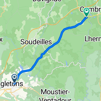
Égletons - Circle to the North through Péret-Bel-Air, Commerly, and St.-Yrieix-le-Déjalat
A cycling route starting in Égletons, Nouvelle-Aquitaine, France.
Overview
About this route
All excellent roads. All were zero and very low traffic roads with nice scenery.
- 4 h 12 min
- Duration
- 49.9 km
- Distance
- 909 m
- Ascent
- 916 m
- Descent
- 11.9 km/h
- Avg. speed
- 890 m
- Max. altitude

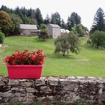
Route photos


Route quality
Waytypes & surfaces along the route
Waytypes
Road
18 km
(36 %)
Quiet road
5 km
(10 %)
Surfaces
Paved
9.5 km
(19 %)
Asphalt
9.5 km
(19 %)
Undefined
40.4 km
(81 %)
Continue with Bikemap
Use, edit, or download this cycling route
You would like to ride Égletons - Circle to the North through Péret-Bel-Air, Commerly, and St.-Yrieix-le-Déjalat or customize it for your own trip? Here is what you can do with this Bikemap route:
Free features
- Save this route as favorite or in collections
- Copy & plan your own version of this route
- Sync your route with Garmin or Wahoo
Premium features
Free trial for 3 days, or one-time payment. More about Bikemap Premium.
- Navigate this route on iOS & Android
- Export a GPX / KML file of this route
- Create your custom printout (try it for free)
- Download this route for offline navigation
Discover more Premium features.
Get Bikemap PremiumFrom our community
Other popular routes starting in Égletons
 Égletons bis Clermont-Ferrand optimiert
- Distance
- 125.5 km
- Ascent
- 2,153 m
- Descent
- 2,363 m
- Location
- Égletons, Nouvelle-Aquitaine, France
 Égletons to Bort-les-Orgues
- Distance
- 51.4 km
- Ascent
- 769 m
- Descent
- 968 m
- Location
- Égletons, Nouvelle-Aquitaine, France
 Égletons - Circle by Darnets
- Distance
- 24.2 km
- Ascent
- 449 m
- Descent
- 451 m
- Location
- Égletons, Nouvelle-Aquitaine, France
 Marcillac-la-Croisille to Bugeat - V87
- Distance
- 70.3 km
- Ascent
- 1,015 m
- Descent
- 948 m
- Location
- Égletons, Nouvelle-Aquitaine, France
 Égletons - Circle to the North through Péret-Bel-Air, Commerly, and St.-Yrieix-le-Déjalat
- Distance
- 49.9 km
- Ascent
- 909 m
- Descent
- 916 m
- Location
- Égletons, Nouvelle-Aquitaine, France
 Égletons - Circle through Lafage-sur-Sombre
- Distance
- 30.6 km
- Ascent
- 430 m
- Descent
- 435 m
- Location
- Égletons, Nouvelle-Aquitaine, France
 Égletons - Circle to Lamazière-Basse
- Distance
- 35.3 km
- Ascent
- 654 m
- Descent
- 655 m
- Location
- Égletons, Nouvelle-Aquitaine, France
 thiers
- Distance
- 10.7 km
- Ascent
- 244 m
- Descent
- 262 m
- Location
- Égletons, Nouvelle-Aquitaine, France
Open it in the app