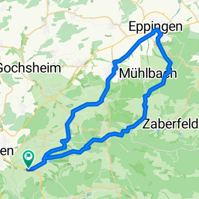
Kraichgaurunde 2016
A cycling route starting in Knittlingen, Baden-Württemberg, Germany.
Overview
About this route
- -:--
- Duration
- 47.3 km
- Distance
- 569 m
- Ascent
- 569 m
- Descent
- ---
- Avg. speed
- ---
- Avg. speed
Route quality
Waytypes & surfaces along the route
Waytypes
Track
35.7 km
(75 %)
Path
7.6 km
(16 %)
Surfaces
Paved
16.3 km
(34 %)
Unpaved
28.2 km
(60 %)
Gravel
15.5 km
(33 %)
Asphalt
10.6 km
(22 %)
Continue with Bikemap
Use, edit, or download this cycling route
You would like to ride Kraichgaurunde 2016 or customize it for your own trip? Here is what you can do with this Bikemap route:
Free features
- Save this route as favorite or in collections
- Copy & plan your own version of this route
- Sync your route with Garmin or Wahoo
Premium features
Free trial for 3 days, or one-time payment. More about Bikemap Premium.
- Navigate this route on iOS & Android
- Export a GPX / KML file of this route
- Create your custom printout (try it for free)
- Download this route for offline navigation
Discover more Premium features.
Get Bikemap PremiumFrom our community
Other popular routes starting in Knittlingen
- Rund um die Melanchthonstadt Bretten - RTF des Rad-Sport-Club Bretten e.V. - 73 km Strecke
- Distance
- 77.2 km
- Ascent
- 664 m
- Descent
- 663 m
- Location
- Knittlingen, Baden-Württemberg, Germany
- Rund um die Melanchthonstadt Bretten - RTF des Rad-Sport-Club Bretten e.V. - 42 km Strecke
- Distance
- 44.7 km
- Ascent
- 476 m
- Descent
- 476 m
- Location
- Knittlingen, Baden-Württemberg, Germany
- Seen-Tour
- Distance
- 30 km
- Ascent
- 317 m
- Descent
- 317 m
- Location
- Knittlingen, Baden-Württemberg, Germany
- Rundfahrt CTF / RSC Bretten
- Distance
- 33.7 km
- Ascent
- 415 m
- Descent
- 415 m
- Location
- Knittlingen, Baden-Württemberg, Germany
- Kraichgau 2017
- Distance
- 47.8 km
- Ascent
- 527 m
- Descent
- 526 m
- Location
- Knittlingen, Baden-Württemberg, Germany
- Rund um Maulbronn
- Distance
- 32.5 km
- Ascent
- 275 m
- Descent
- 275 m
- Location
- Knittlingen, Baden-Württemberg, Germany
- Kraichgaurunde 2016
- Distance
- 47.3 km
- Ascent
- 569 m
- Descent
- 569 m
- Location
- Knittlingen, Baden-Württemberg, Germany
- Kraichgau-Stromberg Besen-Tour
- Distance
- 63.8 km
- Ascent
- 953 m
- Descent
- 954 m
- Location
- Knittlingen, Baden-Württemberg, Germany
Open it in the app