

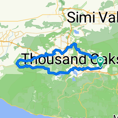
Westlake Loop Route 30 mile ride
A cycling route starting in Agoura, California, United States.
Overview
About this route
you will begin and end in the baskin robbins icecream shop, so you can reward your self with a scoop or two.
- -:--
- Duration
- 52.2 km
- Distance
- 672 m
- Ascent
- 671 m
- Descent
- ---
- Avg. speed
- 427 m
- Max. altitude

Route quality
Waytypes & surfaces along the route
Waytypes
Road
19.8 km
(38 %)
Quiet road
9.9 km
(19 %)
Surfaces
Paved
18.3 km
(35 %)
Asphalt
16.7 km
(32 %)
Concrete
1 km
(2 %)
Continue with Bikemap
Use, edit, or download this cycling route
You would like to ride Westlake Loop Route 30 mile ride or customize it for your own trip? Here is what you can do with this Bikemap route:
Free features
- Save this route as favorite or in collections
- Copy & plan your own version of this route
- Sync your route with Garmin or Wahoo
Premium features
Free trial for 3 days, or one-time payment. More about Bikemap Premium.
- Navigate this route on iOS & Android
- Export a GPX / KML file of this route
- Create your custom printout (try it for free)
- Download this route for offline navigation
Discover more Premium features.
Get Bikemap PremiumFrom our community
Other popular routes starting in Agoura
 Chesbro longer ride
- Distance
- 24.2 km
- Ascent
- 527 m
- Descent
- 527 m
- Location
- Agoura, California, United States
 Easy TO loop through Hidden Valley
- Distance
- 61.9 km
- Ascent
- 461 m
- Descent
- 462 m
- Location
- Agoura, California, United States
 5827 Kanan Rd, Agoura Hills to 5827 Kanan Rd, Agoura Hills
- Distance
- 47.7 km
- Ascent
- 736 m
- Descent
- 734 m
- Location
- Agoura, California, United States
 Mullholland Highway to Cornell Rd
- Distance
- 21.4 km
- Ascent
- 274 m
- Descent
- 269 m
- Location
- Agoura, California, United States
 Cheseboro Canyon
- Distance
- 14.9 km
- Ascent
- 243 m
- Descent
- 244 m
- Location
- Agoura, California, United States
 Road2
Road2- Distance
- 6 km
- Ascent
- 139 m
- Descent
- 136 m
- Location
- Agoura, California, United States
 To Albertson's motorway and gas pipe
- Distance
- 28.9 km
- Ascent
- 663 m
- Descent
- 663 m
- Location
- Agoura, California, United States
 Chesebro Road 5918, Agoura Hills to Chesebro Road 5918, Agoura Hills
- Distance
- 9.8 km
- Ascent
- 50 m
- Descent
- 18 m
- Location
- Agoura, California, United States
Open it in the app