
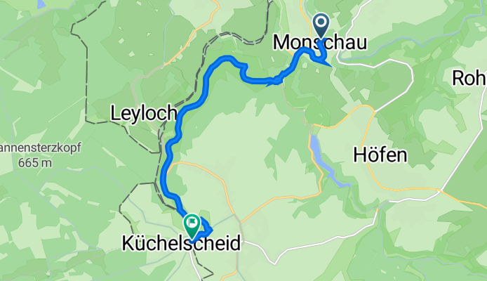
Stehlings 1, Monschau nach Auf dem Hau, Bütgenbach
A cycling route starting in Monschau, North Rhine-Westphalia, Germany.
Overview
About this route
- 39 min
- Duration
- 8 km
- Distance
- 152 m
- Ascent
- 48 m
- Descent
- 12.3 km/h
- Avg. speed
- 520 m
- Avg. speed
Route quality
Waytypes & surfaces along the route
Waytypes
Track
5.3 km
(67 %)
Living street
0.7 km
(8 %)
Surfaces
Paved
2.2 km
(27 %)
Unpaved
4.7 km
(58 %)
Loose gravel
3.2 km
(39 %)
Asphalt
2.1 km
(26 %)
Continue with Bikemap
Use, edit, or download this cycling route
You would like to ride Stehlings 1, Monschau nach Auf dem Hau, Bütgenbach or customize it for your own trip? Here is what you can do with this Bikemap route:
Free features
- Save this route as favorite or in collections
- Copy & plan your own version of this route
- Sync your route with Garmin or Wahoo
Premium features
Free trial for 3 days, or one-time payment. More about Bikemap Premium.
- Navigate this route on iOS & Android
- Export a GPX / KML file of this route
- Create your custom printout (try it for free)
- Download this route for offline navigation
Discover more Premium features.
Get Bikemap PremiumFrom our community
Other popular routes starting in Monschau
 Volg de Rur
- Distance
- 18.1 km
- Ascent
- 271 m
- Descent
- 271 m
- Location
- Monschau, North Rhine-Westphalia, Germany
 Vennbahn Day 5 , Monschau to Eupen, via Wesertalsperre
- Distance
- 43.4 km
- Ascent
- 487 m
- Descent
- 623 m
- Location
- Monschau, North Rhine-Westphalia, Germany
 VB Loop W High Fens, Monschau
- Distance
- 39.7 km
- Ascent
- 662 m
- Descent
- 659 m
- Location
- Monschau, North Rhine-Westphalia, Germany
 VB Monschau to Roetgen
- Distance
- 20.9 km
- Ascent
- 164 m
- Descent
- 147 m
- Location
- Monschau, North Rhine-Westphalia, Germany
 Vennbahn: Day 4 - Monschau to Eupen
- Distance
- 29.8 km
- Ascent
- 312 m
- Descent
- 443 m
- Location
- Monschau, North Rhine-Westphalia, Germany
 Rurseerunde
- Distance
- 43.8 km
- Ascent
- 697 m
- Descent
- 695 m
- Location
- Monschau, North Rhine-Westphalia, Germany
 Kalterherberg - Botrange - Gileppe - Hokai - Botrange - Kalterherberg
- Distance
- 62.4 km
- Ascent
- 753 m
- Descent
- 646 m
- Location
- Monschau, North Rhine-Westphalia, Germany
 Rondje stuwmeer 100km
- Distance
- 101.6 km
- Ascent
- 1,262 m
- Descent
- 1,262 m
- Location
- Monschau, North Rhine-Westphalia, Germany
Open it in the app