
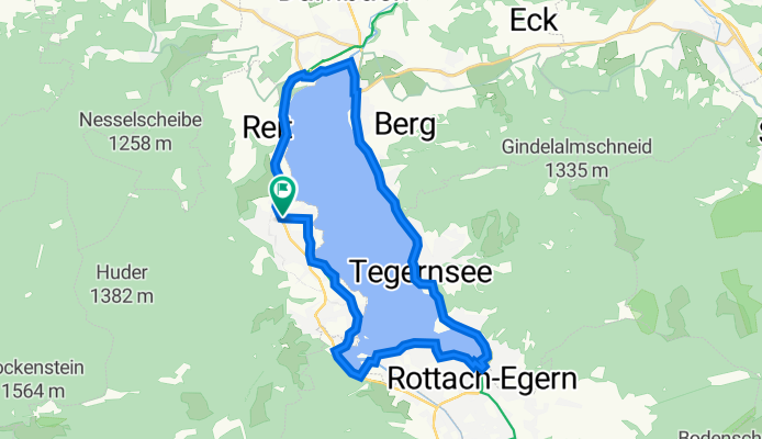
Anton-von-Rieppel-Straße 1, Bad Wiessee to Anton-von-Rieppel-Straße 1, Bad Wiessee
A cycling route starting in Bad Wiessee, Bavaria, Germany.
Overview
About this route
- 1 h 9 min
- Duration
- 19.6 km
- Distance
- 172 m
- Ascent
- 173 m
- Descent
- 17 km/h
- Avg. speed
- 764 m
- Max. altitude
Route quality
Waytypes & surfaces along the route
Waytypes
Quiet road
5.1 km
(26 %)
Cycleway
4.4 km
(23 %)
Surfaces
Paved
15.9 km
(81 %)
Unpaved
2.7 km
(14 %)
Asphalt
15.1 km
(77 %)
Gravel
2.1 km
(11 %)
Continue with Bikemap
Use, edit, or download this cycling route
You would like to ride Anton-von-Rieppel-Straße 1, Bad Wiessee to Anton-von-Rieppel-Straße 1, Bad Wiessee or customize it for your own trip? Here is what you can do with this Bikemap route:
Free features
- Save this route as favorite or in collections
- Copy & plan your own version of this route
- Sync your route with Garmin or Wahoo
Premium features
Free trial for 3 days, or one-time payment. More about Bikemap Premium.
- Navigate this route on iOS & Android
- Export a GPX / KML file of this route
- Create your custom printout (try it for free)
- Download this route for offline navigation
Discover more Premium features.
Get Bikemap PremiumFrom our community
Other popular routes starting in Bad Wiessee
 Fockenstein Umrundung
- Distance
- 38.4 km
- Ascent
- 1,276 m
- Descent
- 1,276 m
- Location
- Bad Wiessee, Bavaria, Germany
 Tegernsee-Runde
- Distance
- 20.4 km
- Ascent
- 147 m
- Descent
- 149 m
- Location
- Bad Wiessee, Bavaria, Germany
 Transalp 2009
- Distance
- 415.3 km
- Ascent
- 7,144 m
- Descent
- 7,816 m
- Location
- Bad Wiessee, Bavaria, Germany
 Schwarze Tenn - Runde
- Distance
- 28.1 km
- Ascent
- 386 m
- Descent
- 386 m
- Location
- Bad Wiessee, Bavaria, Germany
 T20_Hirschberg
- Distance
- 40.1 km
- Ascent
- 1,160 m
- Descent
- 1,160 m
- Location
- Bad Wiessee, Bavaria, Germany
 Um den Hirschberg
- Distance
- 27.9 km
- Ascent
- 365 m
- Descent
- 365 m
- Location
- Bad Wiessee, Bavaria, Germany
 Bad Wiessee - Lengries - Glashütte - Scharling
- Distance
- 52.7 km
- Ascent
- 1,346 m
- Descent
- 1,346 m
- Location
- Bad Wiessee, Bavaria, Germany
 Schinderrunde Tegernsee
- Distance
- 59 km
- Ascent
- 1,195 m
- Descent
- 1,195 m
- Location
- Bad Wiessee, Bavaria, Germany
Open it in the app