

Links und rechts vom oberen Neckartal
A cycling route starting in Oberndorf, Baden-Wurttemberg, Germany.
Overview
About this route
Very beautiful tour passing wonderful viewpoints and ruins as well as inhabited castles.
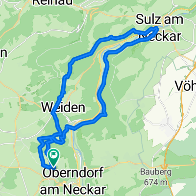
Start and parking in Oberndorf near the town hall (monastery church).
From here, it goes up to the old town and then on to the Gasthaus Stockbrunnen. Then past the ruin Waseneck and back onto the asphalt road on the plateau towards Höhingen. Before Höhingen, in a sharp left curve, we leave the road and ride straight on a good forest road until we reach the road from Höhingen again. Here, right and on the next street left to the Marienkapelle. Now it goes down to Epfendorf and on the Neckar valley cycle path to Talhausen. We leave the cycle path after the railway track to the right, cross the B14 and ride on asphalt to Herrenzimmern. From here, a footpath leads to the ruin Herrenzimmern (possible stop for refreshments). On the driving path, it goes uphill to the district road, now left past farms and through a hollow way down to the B14 which is crossed to reach Talhausen station. Then cross the Neckar (wooden bridge) and uphill to Hohenstein Castle. On the plateau, it goes past the Dietingen rest stop to the field cross, now left and almost straight ahead to a large shed. Here, left to Tierstein and back here again. Now on and the second street right then left down into the Schlichem valley, continuing almost to the Neckar bridge, here right uphill between houses to the nursery and on the path to the street. After a few metres, right up to the Kapf cross. From here a little further up and along the forest edge to the street. Before Harthausen, left through the Madertal valley over the district road to the Schenkenburg ruin. Back to the district road and uphill to the sports ground, then left (at the highest point wonderful view to Lichtenegg Castle) and at the first houses left down into the Schenkenbach valley and immediately back up to Lichtenegg Castle. On the path to the street which is immediately left again. Now down on the lane to Altoberndorf (shortly after the sharp right turn you can still go to the Altoberndorf mountain chapel) where you join the Neckar valley cycle path which leads back to Oberndorf and to the parking lot.
- -:--
- Duration
- 54.9 km
- Distance
- 787 m
- Ascent
- 689 m
- Descent
- ---
- Avg. speed
- ---
- Max. altitude

Route quality
Waytypes & surfaces along the route
Waytypes
Quiet road
24.7 km
(45 %)
Track
17 km
(31 %)
Surfaces
Paved
23.1 km
(42 %)
Unpaved
12.1 km
(22 %)
Asphalt
18.1 km
(33 %)
Unpaved (undefined)
6 km
(11 %)
Route highlights
Points of interest along the route
Point of interest after 4.8 km
Ruine Waseneck
Point of interest after 9.8 km
Marien Kapelle über Epfendorf
Point of interest after 17.9 km
Burgruine Herrenzimmern sehr schöne Anlage. Am Wochenende Einkehr möglich.
Point of interest after 22.8 km
Schloss Hohenstein
Point of interest after 23.6 km
Autobahnraststätte Dietingen etwa 400m vom Schloss Hohenstein entfernt.
Point of interest after 24.4 km
Feldkreuz
Point of interest after 27.7 km
Tierstein Blick ins Neckartal
Point of interest after 32 km
Schlichemklamm ist ein Abstecher wert.(eventuell ohne Bike)
Point of interest after 32.3 km
Ruine Irslingen
Point of interest after 35.6 km
Gärtnerei
Point of interest after 36.8 km
Kapfkreuz schöne Aussicht ins Neckartal
Point of interest after 40 km
Ruine Schenkenburg
Point of interest after 41.1 km
Tennis und Sportheim
Point of interest after 41.5 km
Herrlicher blick auf Schloss Lichtenstein
Point of interest after 42.4 km
Scloss Lichtenegg
Point of interest after 54.9 km
Bergkapelle Altoberndorf
Continue with Bikemap
Use, edit, or download this cycling route
You would like to ride Links und rechts vom oberen Neckartal or customize it for your own trip? Here is what you can do with this Bikemap route:
Free features
- Save this route as favorite or in collections
- Copy & plan your own version of this route
- Sync your route with Garmin or Wahoo
Premium features
Free trial for 3 days, or one-time payment. More about Bikemap Premium.
- Navigate this route on iOS & Android
- Export a GPX / KML file of this route
- Create your custom printout (try it for free)
- Download this route for offline navigation
Discover more Premium features.
Get Bikemap PremiumFrom our community
Other popular routes starting in Oberndorf
 Neckartal und Stausee Schömberg
- Distance
- 52.4 km
- Ascent
- 576 m
- Descent
- 588 m
- Location
- Oberndorf, Baden-Wurttemberg, Germany
 Bochingen Kloster Kirchberg
- Distance
- 27.6 km
- Ascent
- 357 m
- Descent
- 358 m
- Location
- Oberndorf, Baden-Wurttemberg, Germany
 Kleine "Flugplatzrunde"
- Distance
- 20.9 km
- Ascent
- 117 m
- Descent
- 112 m
- Location
- Oberndorf, Baden-Wurttemberg, Germany
 Weiden-Freudenstadt-Weiden
- Distance
- 58.1 km
- Ascent
- 868 m
- Descent
- 959 m
- Location
- Oberndorf, Baden-Wurttemberg, Germany
 Lindenhof-Dunningen
- Distance
- 38.2 km
- Ascent
- 210 m
- Descent
- 211 m
- Location
- Oberndorf, Baden-Wurttemberg, Germany
 Links und rechts vom oberen Neckartal
- Distance
- 54.9 km
- Ascent
- 787 m
- Descent
- 689 m
- Location
- Oberndorf, Baden-Wurttemberg, Germany
 Vatertagstour zur Struthütte
- Distance
- 57.4 km
- Ascent
- 405 m
- Descent
- 417 m
- Location
- Oberndorf, Baden-Wurttemberg, Germany
 Lindenhof - Sulz
- Distance
- 25.7 km
- Ascent
- 340 m
- Descent
- 336 m
- Location
- Oberndorf, Baden-Wurttemberg, Germany
Open it in the app