

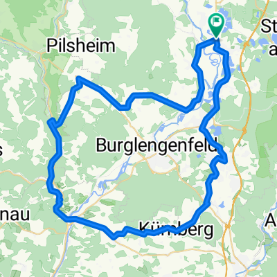
B2-4/Saale 4a kurz: Ettmannsdorf-West - Weiden, Am Tor, 57,4km, 170hm
A cycling route starting in Schwandorf in Bayern, Bavaria, Germany.
Overview
About this route
Ettmannsdorf-West/Schwandorf - (Naabtal Cycle Path) - Krondorf - Irrenlohe - Schwarzenfeld - Wölsendorf with bathing spot?? - Nabburg - Untersteinbach - bathing spot Wernberg - Wernberg-Köblitz - Kettnitzmühle - Grünau - Luhe-Wildenau - (Waldnaab Cycle Path) - Pirk - Rothenstadt - Weiden in the Upper Palatinate Klassik Hotel am Tor, Schlörplatz 1a, 92637 Weiden,
- -:--
- Duration
- 57.4 km
- Distance
- 256 m
- Ascent
- 240 m
- Descent
- ---
- Avg. speed
- 406 m
- Max. altitude

Route quality
Waytypes & surfaces along the route
Waytypes
Quiet road
24.7 km
(43 %)
Track
13.2 km
(23 %)
Surfaces
Paved
43.6 km
(76 %)
Unpaved
7.5 km
(13 %)
Asphalt
41.3 km
(72 %)
Gravel
5.2 km
(9 %)
Route highlights
Points of interest along the route
Point of interest after 16.2 km
Badestelle Wölsendorf???
Point of interest after 17.9 km
Badestelle???
Point of interest after 30.9 km
Badeweiher Wernberg?
Point of interest after 40.7 km
Badestelle Luhe?
Continue with Bikemap
Use, edit, or download this cycling route
You would like to ride B2-4/Saale 4a kurz: Ettmannsdorf-West - Weiden, Am Tor, 57,4km, 170hm or customize it for your own trip? Here is what you can do with this Bikemap route:
Free features
- Save this route as favorite or in collections
- Copy & plan your own version of this route
- Sync your route with Garmin or Wahoo
Premium features
Free trial for 3 days, or one-time payment. More about Bikemap Premium.
- Navigate this route on iOS & Android
- Export a GPX / KML file of this route
- Create your custom printout (try it for free)
- Download this route for offline navigation
Discover more Premium features.
Get Bikemap PremiumFrom our community
Other popular routes starting in Schwandorf in Bayern
 Zur Alten Hochstraße
- Distance
- 19.4 km
- Ascent
- 207 m
- Descent
- 207 m
- Location
- Schwandorf in Bayern, Bavaria, Germany
 Drei-Schlösser-Runde
- Distance
- 55.7 km
- Ascent
- 398 m
- Descent
- 398 m
- Location
- Schwandorf in Bayern, Bavaria, Germany
 Kallmünz übers Vilstal
- Distance
- 57.9 km
- Ascent
- 330 m
- Descent
- 333 m
- Location
- Schwandorf in Bayern, Bavaria, Germany
 Angerring 35, Schwandorf nach Angerring 34, Schwandorf
- Distance
- 17.4 km
- Ascent
- 199 m
- Descent
- 198 m
- Location
- Schwandorf in Bayern, Bavaria, Germany
 Oberpfälzisch-Fränkische Jakobsweg
- Distance
- 123.1 km
- Ascent
- 745 m
- Descent
- 801 m
- Location
- Schwandorf in Bayern, Bavaria, Germany
 Kallmünz übers Vilstal
- Distance
- 57.9 km
- Ascent
- 340 m
- Descent
- 343 m
- Location
- Schwandorf in Bayern, Bavaria, Germany
 Rund um Naabeck
- Distance
- 18.7 km
- Ascent
- 159 m
- Descent
- 159 m
- Location
- Schwandorf in Bayern, Bavaria, Germany
 B2-4/Saale 4a kurz: Ettmannsdorf-West - Weiden, Am Tor, 57,4km, 170hm
- Distance
- 57.4 km
- Ascent
- 256 m
- Descent
- 240 m
- Location
- Schwandorf in Bayern, Bavaria, Germany
Open it in the app