

Alb Extrem 2007 - 190 km
A cycling route starting in Ottenbach, Baden-Wurttemberg, Germany.
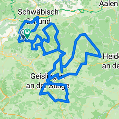
Overview
About this route
The cult event Length according to bike computer: 191 km Organizer's information: 2800 m elevation gain Due to road construction work, detours are often necessary, so the length varies slightly from year to year. Slope quotient: 15.3 m elevation/km Reference: Alb Extrem 06, 190 km 14.7 m elevation/km
- -:--
- Duration
- 189.2 km
- Distance
- 2,989 m
- Ascent
- 2,852 m
- Descent
- ---
- Avg. speed
- 708 m
- Max. altitude

Route quality
Waytypes & surfaces along the route
Waytypes
Road
51.1 km
(27 %)
Quiet road
36 km
(19 %)
Surfaces
Paved
136.2 km
(72 %)
Unpaved
1.9 km
(1 %)
Asphalt
134.4 km
(71 %)
Paved (undefined)
1.9 km
(1 %)
Route highlights
Points of interest along the route
Point of interest after 50.8 km
1. Kontrollpunkt + Verpflegung
Point of interest after 58.1 km
Alb Extrem 2008: Bruch des Nabenflansches am HR
Point of interest after 59.1 km
Furtlepass Passhöhe 630 m
Point of interest after 87.6 km
2. Kontrollpunkt + Verpflegung
Point of interest after 113.9 km
3. Kontrolle
Point of interest after 134.8 km
4. Kontrolle + Verpflegung
Point of interest after 160.6 km
5. Kontrolle + Verpflegung
Continue with Bikemap
Use, edit, or download this cycling route
You would like to ride Alb Extrem 2007 - 190 km or customize it for your own trip? Here is what you can do with this Bikemap route:
Free features
- Save this route as favorite or in collections
- Copy & plan your own version of this route
- Split it into stages to create a multi-day tour
- Sync your route with Garmin or Wahoo
Premium features
Free trial for 3 days, or one-time payment. More about Bikemap Premium.
- Navigate this route on iOS & Android
- Export a GPX / KML file of this route
- Create your custom printout (try it for free)
- Download this route for offline navigation
Discover more Premium features.
Get Bikemap PremiumFrom our community
Other popular routes starting in Ottenbach
 Alb-Extrem_80 km
- Distance
- 79.4 km
- Ascent
- 1,281 m
- Descent
- 1,290 m
- Location
- Ottenbach, Baden-Wurttemberg, Germany
 20130630 Alb-Extrem 210km
- Distance
- 207.7 km
- Ascent
- 2,218 m
- Descent
- 2,218 m
- Location
- Ottenbach, Baden-Wurttemberg, Germany
 Albextrem 2013 - 260 km
- Distance
- 265.1 km
- Ascent
- 2,766 m
- Descent
- 2,779 m
- Location
- Ottenbach, Baden-Wurttemberg, Germany
 Alb Extrem 2008 - 200 km
- Distance
- 195.4 km
- Ascent
- 2,378 m
- Descent
- 2,253 m
- Location
- Ottenbach, Baden-Wurttemberg, Germany
 tour1
tour1- Distance
- 211.6 km
- Ascent
- 3,154 m
- Descent
- 2,990 m
- Location
- Ottenbach, Baden-Wurttemberg, Germany
 Albextrem2022 260 km
- Distance
- 257.2 km
- Ascent
- 4,675 m
- Descent
- 4,685 m
- Location
- Ottenbach, Baden-Wurttemberg, Germany
 Alb Extrem 2007 - 190 km
- Distance
- 189.2 km
- Ascent
- 2,989 m
- Descent
- 2,852 m
- Location
- Ottenbach, Baden-Wurttemberg, Germany
 Alb Extrem 190
- Distance
- 189.7 km
- Ascent
- 2,899 m
- Descent
- 2,776 m
- Location
- Ottenbach, Baden-Wurttemberg, Germany
Open it in the app