- 82 km
- 472 m
- 476 m
- Cologne, North Rhine-Westphalia, Germany
Stadtführung Köln, Spaziergang oder Radtour Süd von www.stadtspiele - verlag.de
A cycling route starting in Cologne, North Rhine-Westphalia, Germany.
Overview
About this route
The route starts at Neumarkt and leads through Südstadt, the Lateng district, and the nightlife area Ringe to the Bermuda Triangle around the Hahnnentor. It touches 26 major sights in the south and west of the city. More information about the sights and geographic data at www.stadtspiele-verlag.de
- -:--
- Duration
- 14.8 km
- Distance
- 56 m
- Ascent
- 52 m
- Descent
- ---
- Avg. speed
- ---
- Max. altitude
created this 13 years ago
Route highlights
Points of interest along the route

Point of interest after 0 km

Point of interest after 0 km

Point of interest after 0.7 km

Point of interest after 0.9 km

Point of interest after 1.3 km

Point of interest after 1.3 km

Point of interest after 1.4 km

Point of interest after 1.6 km

Point of interest after 2.2 km

Point of interest after 2.6 km

Point of interest after 2.7 km

Point of interest after 3 km

Point of interest after 3.6 km

Point of interest after 4.2 km

Point of interest after 7 km

Point of interest after 8.1 km

Point of interest after 8.7 km

Point of interest after 9.8 km

Point of interest after 10.1 km

Point of interest after 11.4 km

Point of interest after 12.1 km

Point of interest after 12.6 km

Point of interest after 14.4 km

Point of interest after 14.8 km
Continue with Bikemap
Use, edit, or download this cycling route
You would like to ride Stadtführung Köln, Spaziergang oder Radtour Süd von www.stadtspiele - verlag.de or customize it for your own trip? Here is what you can do with this Bikemap route:
Free features
- Save this route as favorite or in collections
- Copy & plan your own version of this route
- Sync your route with Garmin or Wahoo
Premium features
Free trial for 3 days, or one-time payment. More about Bikemap Premium.
- Navigate this route on iOS & Android
- Export a GPX / KML file of this route
- Create your custom printout (try it for free)
- Download this route for offline navigation
Discover more Premium features.
Get Bikemap PremiumFrom our community
Other popular routes starting in Cologne
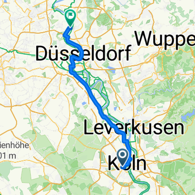
- Köln - Burscheid 82 km
- Breite Straße 133, Köln to Eisenstraße 3, Köln
- 3.2 km
- 12 m
- 13 m
- Cologne, North Rhine-Westphalia, Germany
- Schloss Gymnich
- 61 km
- 201 m
- 201 m
- Cologne, North Rhine-Westphalia, Germany
- Rheinhaufer - Grüngürtel-Aachener
- 23.8 km
- 168 m
- 170 m
- Cologne, North Rhine-Westphalia, Germany
- Route um die Kölner Weiher
- 41.1 km
- 119 m
- 119 m
- Cologne, North Rhine-Westphalia, Germany
- Von Köln bis Meerbusch
- 61.9 km
- 169 m
- 194 m
- Cologne, North Rhine-Westphalia, Germany
- Zievernischer Mühle - Bergheim
- 55.9 km
- 187 m
- 190 m
- Cologne, North Rhine-Westphalia, Germany
- 25km Köln
- 26.7 km
- 209 m
- 199 m
- Cologne, North Rhine-Westphalia, Germany
Open it in the app


