

Tour 9 (Landkreis Amberg-Sulzbach)
A cycling route starting in Etzelwang, Bavaria, Germany.
Overview
About this route
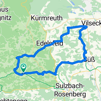
Von Neukirchen aus (Pendolinoanbindung) geht es in das romantische Hirschbachtal (Felsformationen) und dann über Schmidtstadt in die Gemeinde Hirschbach. Der malerische Ort bietet mit einem Modellflugplatz, Ballonfahrten, sehr guten Klettermöglichkeiten und einem Freibad ein breites Freizeitangebot. Weiter geht es über leicht ansteigendes Gelände nach Achtel bis Fichtenhof. Über Holnstein (Burgruine) führt Sie der Weg zurück auf den Fünf-Flüsse-Radweg, auf dem Sie bis Neukirchen bleiben. Ein Abstecher zur Osterhöhle bei Trondorf lohnt sich, wobei die Höhle nur am Wochenende geöffnet ist.
- -:--
- Duration
- 34.5 km
- Distance
- 471 m
- Ascent
- 454 m
- Descent
- ---
- Avg. speed
- 545 m
- Max. altitude
Route quality
Waytypes & surfaces along the route
Waytypes
Road
13.3 km
(38 %)
Quiet road
12 km
(35 %)
Surfaces
Paved
29.5 km
(86 %)
Unpaved
4.8 km
(14 %)
Asphalt
29.2 km
(85 %)
Gravel
4.5 km
(13 %)
Continue with Bikemap
Use, edit, or download this cycling route
You would like to ride Tour 9 (Landkreis Amberg-Sulzbach) or customize it for your own trip? Here is what you can do with this Bikemap route:
Free features
- Save this route as favorite or in collections
- Copy & plan your own version of this route
- Sync your route with Garmin or Wahoo
Premium features
Free trial for 3 days, or one-time payment. More about Bikemap Premium.
- Navigate this route on iOS & Android
- Export a GPX / KML file of this route
- Create your custom printout (try it for free)
- Download this route for offline navigation
Discover more Premium features.
Get Bikemap PremiumFrom our community
Other popular routes starting in Etzelwang
 Neukirchen-Neuhaus-Hohenstadt-Neukirchen
- Distance
- 59.9 km
- Ascent
- 462 m
- Descent
- 485 m
- Location
- Etzelwang, Bavaria, Germany
 Radtour 2025 - Etappe 2
- Distance
- 98.1 km
- Ascent
- 1,270 m
- Descent
- 1,185 m
- Location
- Etzelwang, Bavaria, Germany
 Tour 9 (Landkreis Amberg-Sulzbach)
- Distance
- 34.5 km
- Ascent
- 471 m
- Descent
- 454 m
- Location
- Etzelwang, Bavaria, Germany
 Route 3 - Radrundweg
- Distance
- 20.7 km
- Ascent
- 316 m
- Descent
- 316 m
- Location
- Etzelwang, Bavaria, Germany
 Tour 12 (Landkreis Amberg-Sulzbach)
- Distance
- 45.3 km
- Ascent
- 496 m
- Descent
- 488 m
- Location
- Etzelwang, Bavaria, Germany
 Lehenbachtal - Sebald - Lichtenegg
- Distance
- 28.7 km
- Ascent
- 514 m
- Descent
- 475 m
- Location
- Etzelwang, Bavaria, Germany
 Hubmersberg - Etzelwang - Hartenstein - Korbmachersteig
- Distance
- 41.1 km
- Ascent
- 619 m
- Descent
- 615 m
- Location
- Etzelwang, Bavaria, Germany
 Abgewandelte Radroute Nr. 1
- Distance
- 17.6 km
- Ascent
- 276 m
- Descent
- 275 m
- Location
- Etzelwang, Bavaria, Germany
Open it in the app