Unterallgäuer Natur-Tour
- 22.5 km
- 200 m
- 200 m
- Ottobeuren, Bavaria, Germany
A cycling route starting in Ottobeuren, Bavaria, Germany.
Overview
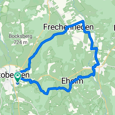
The starting point and the end of the tour are at the marketplace of the spa town of Ottobeuren, below the basilica. (A good opportunity to visit the church before or after completing the route.) From the starting point, you then go right under the basilica up a small hill. (The path is somewhat hidden in a side alley, but is well marked by a sign that prohibits cars from accessing the street from this end.) Now simply follow the course of the road. After a short time, you will see a small playground on the left and shortly after that, the Ottobeurer comprehensive school on your right. Now you go down a small hill again. To the left, just before the end of the road, a bike path begins, where you will soon turn. Follow the bike path to the left, along the Ottobeurer bypass road, until you have the opportunity to turn right towards Hawangen onto the Hawanger Straße. Follow this road until you reach Hawangen. In the village, you will then come to a fork in the road, where you will continue onto Krebsbachweg, which you will follow until you reach the Ringstraße. There, you will turn right. Now follow the road back out of Hawangen. Shortly after the village ends, turn left onto a path that is initially still paved, which soon turns into a dirt road. At the next intersection, turn right. At the next opportunity, turn left again. Now you can follow the dirt road for a few kilometers through the green landscape. After some time, you will need to cross a busy country road. Then, at the next intersection, turn right towards Ungerhausen. You are now on Holzgünzer Straße. Just follow this until you can turn left into Vöhlinstraße. At the end of Vöhlinstraße, turn left again onto the main road. At the second street that now leads to the right, turn in. This now leads directly into the Ungerhausen forest. Just stay on this path until you reach the entrance of Westerheim. (In summer, the forest offers a pleasant and shaded resting place.) Now you drive into the village of Westerheim via Bahnhofstraße. Shortly after a bridge, turn right onto Alte Dorfstraße. At the end of this street, you will reach the main road, onto which you will turn right. Follow this through Oberwesterheim (there, the main road becomes Ottobeurer Straße). On Ottobeurer Straße, you will again leave Westerheim and ride several kilometers through the beautiful landscapes of Unterallgäu, passing by what is known as "Hundsmoor", a small nature reserve. After a few kilometers, Ottobeurer Straße ends at Stephansrieder Weg, where you turn right. Shortly thereafter, a street goes left. Follow it up a hill, through a small place called Klosterwald. After a short time, you reach Eggisried. Here, too, simply continue along the road and pass through the village. At the next intersection, turn right down the hill. Upon reaching the bottom, you will meet St2013, a country road. Cross this to get onto Stephansrieder Straße. At the end of this, turn right onto Langenberger Straße, which soon turns into Bahnhofstraße. Shortly thereafter, you will see the marketplace again on your right. Turn onto it and after a few meters you will have returned to your starting point. Now you have the opportunity to replenish yourself in one of the numerous restaurants or ice cream parlors or visit the "Basilica" (a Baroque church). Guided tours are available from February to November on Saturdays at 14:00.
created this 13 years ago
Route quality
Quiet road
14.9 km
(66 %)
Track
5.4 km
(24 %)
Paved
12.4 km
(55 %)
Unpaved
3.2 km
(14 %)
Asphalt
8.8 km
(39 %)
Paved (undefined)
3.6 km
(16 %)
Route highlights
Ottobeurer Rupppert-Ness Grund-, Haupt-, Realschule und Gymnasium.
Ortseingang Westerheim.
Biegen Sie hier rechts in die Alte Dorfstraße ein.
Nun fahren Sie nach Rechts und folgen der Straße aus dem Ort heraus.
Ortsende Westerheim.
Wunderschöne Unterallgäuer Landschaft genießen, auf der Ottobeurer Straße hinter Westerheim.
Kleines Naturschutzgebiet "Hundsmoor"
Hier fahren Sie nun rechts auf die Stephansrieder Straße und biegen dann gleich in die nächste Straße nach links ab.
Hier befinden Sie sich in Klosterwald. Folgen Sie einfach der Straße durch den kleinen Ort hindurch.
Natur pur genießen zwischen Klosterwald und Eggisried.
In diesem kleinen Ort namens Eggisried folgen Sie einfach weiter der Straße.
Landschaft hinter Eggisried.
Hier biegen Sie rechts ab und können sich nun den Berg Richtung Ottobeuren hinabrollen lassen.
Überqueren Sie nun die Ottobeurer Umgehungsstraße in die Stephansrieder Straße.
An dieser Kreuzung fahren Sie nach rechts in die Ortsmitte Ottobeurens.
Continue with Bikemap
You would like to ride Unterallgäuer Natur-Tour or customize it for your own trip? Here is what you can do with this Bikemap route:
Free trial for 3 days, or one-time payment. More about Bikemap Premium.
Discover more Premium features.
Get Bikemap PremiumFrom our community
Open it in the app