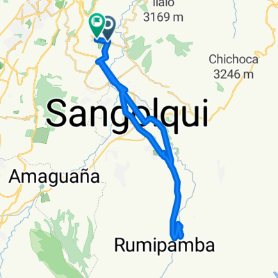
Descubriendo Conocoto II
A cycling route starting in SangolquĆ, Provincia de Pichincha, Ecuador.
Overview
About this route
Una ruta increible para bicicleta de montaƱa, buena vista del valle y por supuesto buenas bajadas!
- -:--
- Duration
- 13.1 km
- Distance
- 346 m
- Ascent
- 351 m
- Descent
- ---
- Avg. speed
- ---
- Avg. speed
Route highlights
Points of interest along the route
Point of interest after 6.6 km
Point of interest after 6.7 km
Continue with Bikemap
Use, edit, or download this cycling route
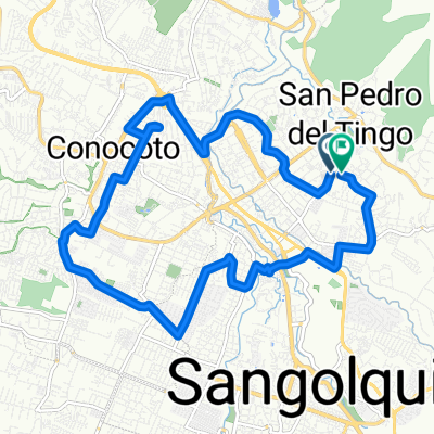
You would like to ride Descubriendo Conocoto II or customize it for your own trip? Here is what you can do with this Bikemap route:
Free features
- Save this route as favorite or in collections
- Copy & plan your own version of this route
- Sync your route with Garmin or Wahoo
Premium features
Free trial for 3 days, or one-time payment. More about Bikemap Premium.
- Navigate this route on iOS & Android
- Export a GPX / KML file of this route
- Create your custom printout (try it for free)
- Download this route for offline navigation
Discover more Premium features.
Get Bikemap PremiumFrom our community
Other popular routes starting in SangolquĆ
- entrada a cotogchoa
- Distance
- 23.5 km
- Ascent
- 424 m
- Descent
- 427 m
- Location
- SangolquĆ, Provincia de Pichincha, Ecuador
- Descubriendo Conocoto II
- Distance
- 13.1 km
- Ascent
- 346 m
- Descent
- 351 m
- Location
- SangolquĆ, Provincia de Pichincha, Ecuador
- AmaguaƱa - Pasochoa 2011
- Distance
- 32.9 km
- Ascent
- 913 m
- Descent
- 913 m
- Location
- SangolquĆ, Provincia de Pichincha, Ecuador
- Club Los chillo-Pasochoa
- Distance
- 28.2 km
- Ascent
- 680 m
- Descent
- 681 m
- Location
- SangolquĆ, Provincia de Pichincha, Ecuador
- cashapamba alto
- Distance
- 29.7 km
- Ascent
- 462 m
- Descent
- 437 m
- Location
- SangolquĆ, Provincia de Pichincha, Ecuador
- parque
- Distance
- 17.5 km
- Ascent
- 582 m
- Descent
- 550 m
- Location
- SangolquĆ, Provincia de Pichincha, Ecuador
- RĆo Pita
- Distance
- 38.7 km
- Ascent
- 0 m
- Descent
- 0 m
- Location
- SangolquĆ, Provincia de Pichincha, Ecuador
- RUTA DE LOS VOLCANES
- Distance
- 37.8 km
- Ascent
- 1,781 m
- Descent
- 612 m
- Location
- SangolquĆ, Provincia de Pichincha, Ecuador
Open it in the app