

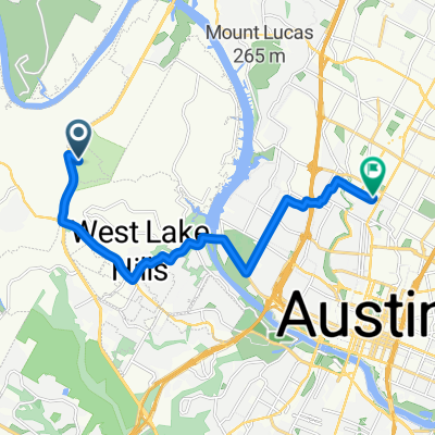
2211 Lanier Dr, Austin to 7100 Woodrow Ave, Austin
A cycling route starting in West Lake Hills, Texas, United States.
Overview
About this route
- 8 min
- Duration
- 2.6 km
- Distance
- 12 m
- Ascent
- 12 m
- Descent
- 21.1 km/h
- Avg. speed
- 232 m
- Max. altitude

Route quality
Waytypes & surfaces along the route
Waytypes
Road
1.7 km
(64 %)
Quiet road
0.8 km
(30 %)
Surfaces
Paved
1.9 km
(73 %)
Asphalt
1.9 km
(73 %)
Undefined
0.7 km
(27 %)
Continue with Bikemap
Use, edit, or download this cycling route
You would like to ride 2211 Lanier Dr, Austin to 7100 Woodrow Ave, Austin or customize it for your own trip? Here is what you can do with this Bikemap route:
Free features
- Save this route as favorite or in collections
- Copy & plan your own version of this route
- Sync your route with Garmin or Wahoo
Premium features
Free trial for 3 days, or one-time payment. More about Bikemap Premium.
- Navigate this route on iOS & Android
- Export a GPX / KML file of this route
- Create your custom printout (try it for free)
- Download this route for offline navigation
Discover more Premium features.
Get Bikemap PremiumFrom our community
Other popular routes starting in West Lake Hills
 Steady ride in Austin
- Distance
- 14.5 km
- Ascent
- 160 m
- Descent
- 236 m
- Location
- West Lake Hills, Texas, United States
 NC to Threadgill's or Styles Switch 3.4
- Distance
- 3.4 km
- Ascent
- 13 m
- Descent
- 12 m
- Location
- West Lake Hills, Texas, United States
 NC to MJ via Shoal Creek and Red River 26
- Distance
- 26.2 km
- Ascent
- 115 m
- Descent
- 115 m
- Location
- West Lake Hills, Texas, United States
 NC to Spectrum circle 20km
- Distance
- 19.5 km
- Ascent
- 76 m
- Descent
- 76 m
- Location
- West Lake Hills, Texas, United States
 Northwest - Industrial Turnaround
- Distance
- 13.9 km
- Ascent
- 67 m
- Descent
- 63 m
- Location
- West Lake Hills, Texas, United States
 blah
blah- Distance
- 42.1 km
- Ascent
- 219 m
- Descent
- 144 m
- Location
- West Lake Hills, Texas, United States
 NC to MJ shortest route 24.6
- Distance
- 24.6 km
- Ascent
- 111 m
- Descent
- 114 m
- Location
- West Lake Hills, Texas, United States
 10/66-Grover/Brentwood/Guad/NLoop/51/Mueller/51/Guad/NLoop/Woodrow/Arroyo
- Distance
- 16.6 km
- Ascent
- 83 m
- Descent
- 85 m
- Location
- West Lake Hills, Texas, United States
Open it in the app