

Tour 12 (Landkreis Amberg-Sulzbach)
A cycling route starting in Etzelwang, Bavaria, Germany.
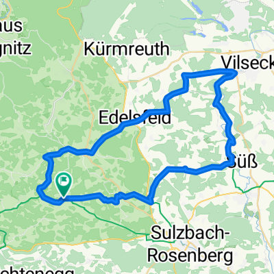
Overview
About this route
Von Neukirchen (Pendolinoanbindung) führt Sie der Weg nach Holnstein (Burg). Von da geht es weiter auf hügeliger Strecke bis Edelsfeld und auf schönen, aussichtsreichen Nebenstrecken hinab ins Vilstal nach Schlicht. Hier treffen Sie auf den Vilstal-Radweg, dem Sie ein kleines Stück folgen. Die Rückfahrt über Iber, Kleinfals und Röckenricht wird wieder hügelig. Die 12-er Strecke ist eine anspruchsvolle, aber wirklich abwechslungsreiche Tour. Mit einer Übernachtung in Vilseck kann die Runde auf 2 Tage ausgedehnt werden.
- -:--
- Duration
- 45.3 km
- Distance
- 496 m
- Ascent
- 488 m
- Descent
- ---
- Avg. speed
- 556 m
- Max. altitude
Route quality
Waytypes & surfaces along the route
Waytypes
Quiet road
21.7 km
(48 %)
Road
11.8 km
(26 %)
Surfaces
Paved
36.9 km
(82 %)
Unpaved
5.1 km
(11 %)
Asphalt
35.9 km
(79 %)
Gravel
3.8 km
(8 %)
Continue with Bikemap
Use, edit, or download this cycling route
You would like to ride Tour 12 (Landkreis Amberg-Sulzbach) or customize it for your own trip? Here is what you can do with this Bikemap route:
Free features
- Save this route as favorite or in collections
- Copy & plan your own version of this route
- Sync your route with Garmin or Wahoo
Premium features
Free trial for 3 days, or one-time payment. More about Bikemap Premium.
- Navigate this route on iOS & Android
- Export a GPX / KML file of this route
- Create your custom printout (try it for free)
- Download this route for offline navigation
Discover more Premium features.
Get Bikemap PremiumFrom our community
Other popular routes starting in Etzelwang
 Radtour 2025 - Etappe 2
- Distance
- 98.1 km
- Ascent
- 1,270 m
- Descent
- 1,185 m
- Location
- Etzelwang, Bavaria, Germany
 Lehenbachtal - Sebald - Lichtenegg
- Distance
- 28.7 km
- Ascent
- 514 m
- Descent
- 475 m
- Location
- Etzelwang, Bavaria, Germany
 Simultankirchen-Radweg Route 2 / Neunkirchen bei Sulzbach Rosenberg
- Distance
- 23 km
- Ascent
- 296 m
- Descent
- 299 m
- Location
- Etzelwang, Bavaria, Germany
 Paneuropa Radweg Nürnberg-Prag Teil 2 CLONED FROM ROUTE 3499
- Distance
- 78 km
- Ascent
- 312 m
- Descent
- 351 m
- Location
- Etzelwang, Bavaria, Germany
 Hauptwasserscheide - Osterhöhle - Peilstein
- Distance
- 12.7 km
- Ascent
- 211 m
- Descent
- 209 m
- Location
- Etzelwang, Bavaria, Germany
 Abgewandelte Radroute Nr. 1
- Distance
- 17.6 km
- Ascent
- 276 m
- Descent
- 275 m
- Location
- Etzelwang, Bavaria, Germany
 Fünf-Flüsse-Radweg_3.Etappe CLONED FROM ROUTE 440421
- Distance
- 68 km
- Ascent
- 260 m
- Descent
- 320 m
- Location
- Etzelwang, Bavaria, Germany
 Tour 12 (Landkreis Amberg-Sulzbach)
- Distance
- 45.3 km
- Ascent
- 496 m
- Descent
- 488 m
- Location
- Etzelwang, Bavaria, Germany
Open it in the app