Rute mit anspruchsvoller Steigung und rasanter Abfahrt
A cycling route starting in Oberstenfeld, Baden-Wurttemberg, Germany.
Overview
About this route
Good for a Sunday in early summer as you can also swim in the Breitenauer Lake. For less ambitious riders, it is possible to ride from the destination, thus skipping the steep ascent over the Löwenstein mountains. For everyone else, generally, caution is advised when using the country road between Prevorst and Löwenstein, which is heavily used by motorcycles.
- -:--
- Duration
- 46.2 km
- Distance
- 824 m
- Ascent
- 811 m
- Descent
- ---
- Avg. speed
- 513 m
- Max. altitude
Route quality
Waytypes & surfaces along the route
Waytypes
Road
11.5 km
(25 %)
Quiet road
11.1 km
(24 %)
Surfaces
Paved
39.2 km
(85 %)
Unpaved
2.3 km
(5 %)
Asphalt
37.9 km
(82 %)
Paved (undefined)
1.4 km
(3 %)
Continue with Bikemap
Use, edit, or download this cycling route
You would like to ride Rute mit anspruchsvoller Steigung und rasanter Abfahrt or customize it for your own trip? Here is what you can do with this Bikemap route:
Free features
- Save this route as favorite or in collections
- Copy & plan your own version of this route
- Sync your route with Garmin or Wahoo
Premium features
Free trial for 3 days, or one-time payment. More about Bikemap Premium.
- Navigate this route on iOS & Android
- Export a GPX / KML file of this route
- Create your custom printout (try it for free)
- Download this route for offline navigation
Discover more Premium features.
Get Bikemap PremiumFrom our community
Other popular routes starting in Oberstenfeld
- Bottwartal-Gronau-Neuwirtshaus-Forsthof-Steinheim
- Distance
- 35.9 km
- Ascent
- 268 m
- Descent
- 394 m
- Location
- Oberstenfeld, Baden-Wurttemberg, Germany
- Ilsfeld - Wunnenstein - Großbottwar
- Distance
- 20.3 km
- Ascent
- 178 m
- Descent
- 178 m
- Location
- Oberstenfeld, Baden-Wurttemberg, Germany
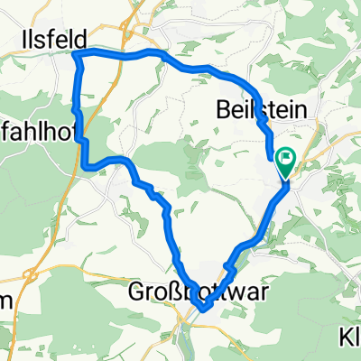
- Radrunde um Oberstenfeld
- Distance
- 42.8 km
- Ascent
- 831 m
- Descent
- 830 m
- Location
- Oberstenfeld, Baden-Wurttemberg, Germany
- Rute mit anspruchsvoller Steigung und rasanter Abfahrt
- Distance
- 46.2 km
- Ascent
- 824 m
- Descent
- 811 m
- Location
- Oberstenfeld, Baden-Wurttemberg, Germany
- Loewensteiner Berge
- Distance
- 61.5 km
- Ascent
- 905 m
- Descent
- 905 m
- Location
- Oberstenfeld, Baden-Wurttemberg, Germany
- Oberstenfeld Sinzenburg
- Distance
- 23.2 km
- Ascent
- 400 m
- Descent
- 400 m
- Location
- Oberstenfeld, Baden-Wurttemberg, Germany
- Gronau zum Breitenauer See
- Distance
- 17.9 km
- Ascent
- 205 m
- Descent
- 218 m
- Location
- Oberstenfeld, Baden-Wurttemberg, Germany
- Gronau - xxx - Gronau
- Distance
- 99.3 km
- Ascent
- 1,104 m
- Descent
- 1,103 m
- Location
- Oberstenfeld, Baden-Wurttemberg, Germany
Open it in the app