

Kolesarska pot od Ruševca do Planice nad Framom
A cycling route starting in Ruše, Ruše Municipality, Slovenia.
Overview
About this route
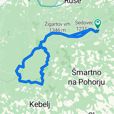
Pot nas pelje od Apartmajske hiše Ruševec, pretežno po asfaltnih cestah, najprej proti Arehu, levo se odcepimo proti Framu/Frajhamu, tukaj se nam odpre čudovita pokrajina hribovskih krajev pretežno kmečkih domačij. Nadaljujemo do Planice nad Framom, kjer nas čaka čudovit razgled z odprte planote na spodno podravje, pogled pa seže vse do Donačke gore in Boča. Izberemo lahko levo ali desno smer križne vožnje po Planici in si ogledamo lokalne znamenitosti. Priporočamo vožnjo v sončnem vremenu, zaradi razglednih točk.
- -:--
- Duration
- 25.9 km
- Distance
- 807 m
- Ascent
- 807 m
- Descent
- ---
- Avg. speed
- ---
- Max. altitude
Route quality
Waytypes & surfaces along the route
Waytypes
Road
16.4 km
(63 %)
Quiet road
6 km
(23 %)
Surfaces
Paved
22.7 km
(88 %)
Unpaved
2 km
(8 %)
Asphalt
22.7 km
(88 %)
Ground
1.1 km
(4 %)
Route highlights
Points of interest along the route
Photo after 0.7 km
Point of interest after 9.3 km
Cestnik
Point of interest after 9.3 km
Cestnikova kapela
Point of interest after 12 km
Pri kovačniku - turizem na kmetiji
Accommodation after 12.1 km
Planinski dom Planica
Point of interest after 12.3 km
Pri Baronu - Turizem na kmetiji
Point of interest after 14.2 km
Cerkev Sv. Križa
Point of interest after 14.7 km
Potnikova smreka
Point of interest after 14.9 km
Vrešnarjeva podzemna jama
Point of interest after 15.1 km
Continue with Bikemap
Use, edit, or download this cycling route
You would like to ride Kolesarska pot od Ruševca do Planice nad Framom or customize it for your own trip? Here is what you can do with this Bikemap route:
Free features
- Save this route as favorite or in collections
- Copy & plan your own version of this route
- Sync your route with Garmin or Wahoo
Premium features
Free trial for 3 days, or one-time payment. More about Bikemap Premium.
- Navigate this route on iOS & Android
- Export a GPX / KML file of this route
- Create your custom printout (try it for free)
- Download this route for offline navigation
Discover more Premium features.
Get Bikemap PremiumFrom our community
Other popular routes starting in Ruše
 Areh - Lovrenška jezera
- Distance
- 54.5 km
- Ascent
- 951 m
- Descent
- 941 m
- Location
- Ruše, Ruše Municipality, Slovenia
 Kolesarska pot od Ruševca do Planice nad Framom
- Distance
- 25.9 km
- Ascent
- 807 m
- Descent
- 807 m
- Location
- Ruše, Ruše Municipality, Slovenia
 Od Apartmajske hiše Ruševec do pragozda in Slapov Šumik
- Distance
- 12.9 km
- Ascent
- 257 m
- Descent
- 431 m
- Location
- Ruše, Ruše Municipality, Slovenia
 Areh-Rogla-Areh
- Distance
- 48.8 km
- Ascent
- 1,078 m
- Descent
- 1,088 m
- Location
- Ruše, Ruše Municipality, Slovenia
 Lobnica to Lukanja
- Distance
- 29 km
- Ascent
- 505 m
- Descent
- 735 m
- Location
- Ruše, Ruše Municipality, Slovenia
 Od Ruševca okrog Črnega jezera in Treh Kraljev
- Distance
- 41.9 km
- Ascent
- 814 m
- Descent
- 814 m
- Location
- Ruše, Ruše Municipality, Slovenia
 Od Ruševca okrog Črnega jezera in Treh Kraljev
- Distance
- 45.4 km
- Ascent
- 837 m
- Descent
- 900 m
- Location
- Ruše, Ruše Municipality, Slovenia
 Nočni pohod
- Distance
- 5.1 km
- Ascent
- 285 m
- Descent
- 288 m
- Location
- Ruše, Ruše Municipality, Slovenia
Open it in the app