

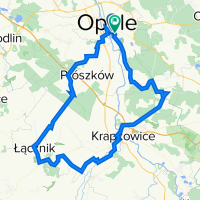
Góra Św Anny
A cycling route starting in Opole, Opole Voivodeship, Poland.
Overview
About this route
Great route for Anka, mainly through the forest - just right for a day trip with camping.
- -:--
- Duration
- 36.6 km
- Distance
- 273 m
- Ascent
- 99 m
- Descent
- ---
- Avg. speed
- ---
- Max. altitude
Continue with Bikemap
Use, edit, or download this cycling route
You would like to ride Góra Św Anny or customize it for your own trip? Here is what you can do with this Bikemap route:
Free features
- Save this route as favorite or in collections
- Copy & plan your own version of this route
- Sync your route with Garmin or Wahoo
Premium features
Free trial for 3 days, or one-time payment. More about Bikemap Premium.
- Navigate this route on iOS & Android
- Export a GPX / KML file of this route
- Create your custom printout (try it for free)
- Download this route for offline navigation
Discover more Premium features.
Get Bikemap PremiumFrom our community
Other popular routes starting in Opole
 Góra Św Anny
- Distance
- 36.6 km
- Ascent
- 273 m
- Descent
- 99 m
- Location
- Opole, Opole Voivodeship, Poland
 Opole_Niemodlin_Lipno_Opole
- Distance
- 89.2 km
- Ascent
- 177 m
- Descent
- 172 m
- Location
- Opole, Opole Voivodeship, Poland
 Dom- Park Wiśniewskiego-wyspa bolko
- Distance
- 9.4 km
- Ascent
- 164 m
- Descent
- 160 m
- Location
- Opole, Opole Voivodeship, Poland
 Turawa Krzaki MATT
- Distance
- 26 km
- Ascent
- 81 m
- Descent
- 81 m
- Location
- Opole, Opole Voivodeship, Poland
 opole moszna kamien opole
- Distance
- 99 km
- Ascent
- 487 m
- Descent
- 484 m
- Location
- Opole, Opole Voivodeship, Poland
 okolice Opola
- Distance
- 66.6 km
- Ascent
- 107 m
- Descent
- 106 m
- Location
- Opole, Opole Voivodeship, Poland
 opole -korfantów -- krapkowice - prószków - opolel
- Distance
- 100.2 km
- Ascent
- 150 m
- Descent
- 150 m
- Location
- Opole, Opole Voivodeship, Poland
 Moderate route in Opole
- Distance
- 18.5 km
- Ascent
- 374 m
- Descent
- 383 m
- Location
- Opole, Opole Voivodeship, Poland
Open it in the app