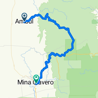
Taninga - Villa Dolores
A cycling route starting in Salsacate, Cordoba Province, Argentina.
Overview
About this route
- -:--
- Duration
- 128.7 km
- Distance
- 537 m
- Ascent
- 994 m
- Descent
- ---
- Avg. speed
- ---
- Max. altitude
Route quality
Waytypes & surfaces along the route
Waytypes
Quiet road
15.4 km
(12 %)
Road
14.2 km
(11 %)
Undefined
99.1 km
(77 %)
Surfaces
Paved
34.7 km
(27 %)
Unpaved
84.9 km
(66 %)
Unpaved (undefined)
73.4 km
(57 %)
Asphalt
34.7 km
(27 %)
Route highlights
Points of interest along the route
Point of interest after 34.5 km
primero de los varios tùneles de este itinerario. hermoso descenso. A no distraerse. Grandes precipicios
Continue with Bikemap
Use, edit, or download this cycling route
You would like to ride Taninga - Villa Dolores or customize it for your own trip? Here is what you can do with this Bikemap route:
Free features
- Save this route as favorite or in collections
- Copy & plan your own version of this route
- Split it into stages to create a multi-day tour
- Sync your route with Garmin or Wahoo
Premium features
Free trial for 3 days, or one-time payment. More about Bikemap Premium.
- Navigate this route on iOS & Android
- Export a GPX / KML file of this route
- Create your custom printout (try it for free)
- Download this route for offline navigation
Discover more Premium features.
Get Bikemap PremiumFrom our community
Other popular routes starting in Salsacate
 VUELTA ALTAS CUMBRES CATEGORÍAS COMPETITIVAS
- Distance
- 79.5 km
- Ascent
- 1,209 m
- Descent
- 1,433 m
- Location
- Salsacate, Cordoba Province, Argentina
 Taninga - Cba por gigantes
- Distance
- 143.6 km
- Ascent
- 1,115 m
- Descent
- 1,716 m
- Location
- Salsacate, Cordoba Province, Argentina
 De Remedios de Escalada, Ambul a Avenida Intendente Vila 1533
- Distance
- 79 km
- Ascent
- 1,824 m
- Descent
- 2,041 m
- Location
- Salsacate, Cordoba Province, Argentina
 Taninga - Los tuneles
- Distance
- 74.1 km
- Ascent
- 775 m
- Descent
- 774 m
- Location
- Salsacate, Cordoba Province, Argentina
 De Remedios de Escalada, Ambul a Olmos Sur 1228
- Distance
- 79.4 km
- Ascent
- 2,064 m
- Descent
- 2,288 m
- Location
- Salsacate, Cordoba Province, Argentina
 De Remedios de Escalada, Ambul a Olmos Sur 1228
- Distance
- 79.4 km
- Ascent
- 1,867 m
- Descent
- 2,091 m
- Location
- Salsacate, Cordoba Province, Argentina
 Taninga - Villa Dolores
- Distance
- 128.7 km
- Ascent
- 537 m
- Descent
- 994 m
- Location
- Salsacate, Cordoba Province, Argentina
 Vuelta Altas Cumbres
- Distance
- 97.2 km
- Ascent
- 1,293 m
- Descent
- 1,494 m
- Location
- Salsacate, Cordoba Province, Argentina
Open it in the app


