

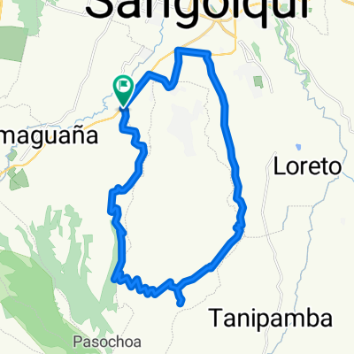
Sangolqui (Quito) - Baños
A cycling route starting in Sangolquí, Pichincha, Ecuador.
Overview
About this route
Two or three days on the road with a tent and some camping supplies. Wild camping in the beautiful Ecuadorian wilderness and visiting the cities. It is possible to use hotels and restaurants on the trip, but you can also camp and bring your own food. Perfect for a group of people or for someone who enjoys the solitude of being out there.
- 13 h 24 min
- Duration
- 194.7 km
- Distance
- 5,054 m
- Ascent
- 5,749 m
- Descent
- 14.5 km/h
- Avg. speed
- 3,867 m
- Max. altitude
Route quality
Waytypes & surfaces along the route
Waytypes
Quiet road
159.6 km
(82 %)
Road
27.3 km
(14 %)
Surfaces
Paved
31.2 km
(16 %)
Unpaved
21.4 km
(11 %)
Asphalt
27.3 km
(14 %)
Ground
11.7 km
(6 %)
Continue with Bikemap
Use, edit, or download this cycling route
You would like to ride Sangolqui (Quito) - Baños or customize it for your own trip? Here is what you can do with this Bikemap route:
Free features
- Save this route as favorite or in collections
- Copy & plan your own version of this route
- Split it into stages to create a multi-day tour
- Sync your route with Garmin or Wahoo
Premium features
Free trial for 3 days, or one-time payment. More about Bikemap Premium.
- Navigate this route on iOS & Android
- Export a GPX / KML file of this route
- Create your custom printout (try it for free)
- Download this route for offline navigation
Discover more Premium features.
Get Bikemap PremiumFrom our community
Other popular routes starting in Sangolquí
 cashapamba alto
- Distance
- 29.7 km
- Ascent
- 462 m
- Descent
- 437 m
- Location
- Sangolquí, Pichincha, Ecuador
 parque
- Distance
- 17.5 km
- Ascent
- 582 m
- Descent
- 550 m
- Location
- Sangolquí, Pichincha, Ecuador
 RUTA DE LOS VOLCANES
- Distance
- 37.8 km
- Ascent
- 1,781 m
- Descent
- 612 m
- Location
- Sangolquí, Pichincha, Ecuador
 Club Los chillo-Pasochoa
- Distance
- 28.2 km
- Ascent
- 680 m
- Descent
- 681 m
- Location
- Sangolquí, Pichincha, Ecuador
 Cotohurco
- Distance
- 30.4 km
- Ascent
- 1,084 m
- Descent
- 1,084 m
- Location
- Sangolquí, Pichincha, Ecuador
 Amaguaña - Pasochoa 2011
- Distance
- 32.9 km
- Ascent
- 913 m
- Descent
- 913 m
- Location
- Sangolquí, Pichincha, Ecuador
 LAGARTIJAS BIKE RACE 15K - 30K
- Distance
- 15.6 km
- Ascent
- 608 m
- Descent
- 609 m
- Location
- Sangolquí, Pichincha, Ecuador
 ANTISANA
- Distance
- 27.6 km
- Ascent
- 1,353 m
- Descent
- 495 m
- Location
- Sangolquí, Pichincha, Ecuador
Open it in the app