
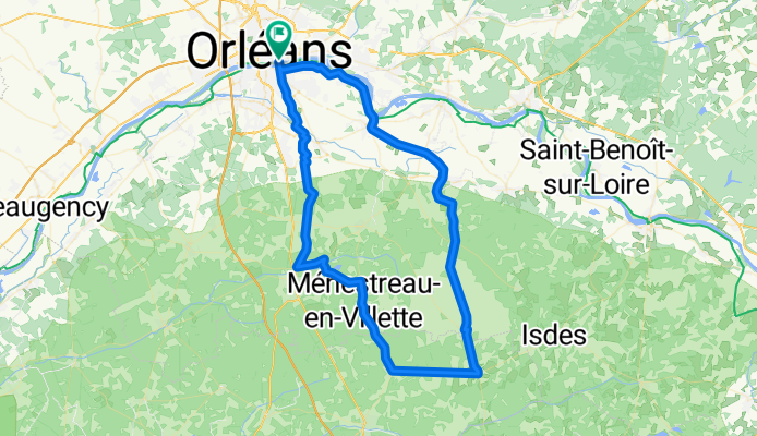
LOIRET - SUD - 88 kms
A cycling route starting in Saint-Jean-le-Blanc, Centre Region, France.
Overview
About this route
SUD ORLEANS --Denivelé :50m--88kms---levée de loire - sandillon--rte de férolle -vienne - (pause a la scierie) - sennely - souvigny en sologne - vouzon - menestreau - dir la ferté - retour par la za la saussaye- piste cyclabe - orleans
- 5 h 22 min
- Duration
- 87.5 km
- Distance
- 260 m
- Ascent
- 260 m
- Descent
- 16.3 km/h
- Avg. speed
- 153 m
- Avg. speed

Route quality
Waytypes & surfaces along the route
Waytypes
Quiet road
34.3 km
(39 %)
Road
24.2 km
(28 %)
Surfaces
Paved
45.1 km
(52 %)
Unpaved
0.1 km
(<1 %)
Asphalt
44.7 km
(51 %)
Wood
0.3 km
(<1 %)
Continue with Bikemap
Use, edit, or download this cycling route
You would like to ride LOIRET - SUD - 88 kms or customize it for your own trip? Here is what you can do with this Bikemap route:
Free features
- Save this route as favorite or in collections
- Copy & plan your own version of this route
- Split it into stages to create a multi-day tour
- Sync your route with Garmin or Wahoo
Premium features
Free trial for 3 days, or one-time payment. More about Bikemap Premium.
- Navigate this route on iOS & Android
- Export a GPX / KML file of this route
- Create your custom printout (try it for free)
- Download this route for offline navigation
Discover more Premium features.
Get Bikemap PremiumFrom our community
Other popular routes starting in Saint-Jean-le-Blanc
 loiret - SO - 81kms
- Distance
- 81.2 km
- Ascent
- 217 m
- Descent
- 217 m
- Location
- Saint-Jean-le-Blanc, Centre Region, France
 LOIRET - SO - 82km orleans
- Distance
- 80.7 km
- Ascent
- 189 m
- Descent
- 192 m
- Location
- Saint-Jean-le-Blanc, Centre Region, France
 LOIRET S-E ORLEANS 95km
- Distance
- 94.8 km
- Ascent
- 330 m
- Descent
- 329 m
- Location
- Saint-Jean-le-Blanc, Centre Region, France
 LOIRET - SO - 92km orleans
- Distance
- 91.6 km
- Ascent
- 226 m
- Descent
- 229 m
- Location
- Saint-Jean-le-Blanc, Centre Region, France
 LOIRET - SUD ORLEANS-marcilly-ciran-la ferté-lailly-levée
- Distance
- 90.6 km
- Ascent
- 298 m
- Descent
- 298 m
- Location
- Saint-Jean-le-Blanc, Centre Region, France
 LOIRET S-E tigy petit parcours 83km
- Distance
- 83.5 km
- Ascent
- 301 m
- Descent
- 300 m
- Location
- Saint-Jean-le-Blanc, Centre Region, France
 LOIRET SO -110KM saran - gidy - beaugency
- Distance
- 109.8 km
- Ascent
- 262 m
- Descent
- 259 m
- Location
- Saint-Jean-le-Blanc, Centre Region, France
 LOIRET - SUD - 88 kms
- Distance
- 87.5 km
- Ascent
- 260 m
- Descent
- 260 m
- Location
- Saint-Jean-le-Blanc, Centre Region, France
Open it in the app