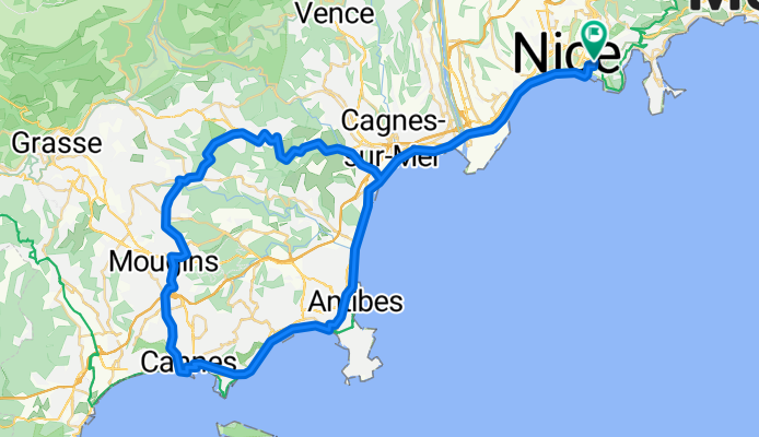
nice-cannes-valbonne
A cycling route starting in Villefranche-sur-Mer, Provence-Alpes-C么te d'Azur Region, France.
Overview
About this route
- -:--
- Duration
- 78.2 km
- Distance
- 423 m
- Ascent
- 425 m
- Descent
- ---
- Avg. speed
- 248 m
- Avg. speed
Route quality
Waytypes & surfaces along the route
Waytypes
Busy road
37.4 km
(48 %)
Cycleway
23.8 km
(31 %)
Surfaces
Paved
73.4 km
(94 %)
Unpaved
0 km
(<1 %)
Asphalt
68.6 km
(88 %)
Paved (undefined)
2.4 km
(3 %)
Continue with Bikemap
Use, edit, or download this cycling route
You would like to ride nice-cannes-valbonne or customize it for your own trip? Here is what you can do with this Bikemap route:
Free features
- Save this route as favorite or in collections
- Copy & plan your own version of this route
- Sync your route with Garmin or Wahoo
Premium features
Free trial for 3 days, or one-time payment. More about Bikemap Premium.
- Navigate this route on iOS & Android
- Export a GPX / KML file of this route
- Create your custom printout (try it for free)
- Download this route for offline navigation
Discover more Premium features.
Get Bikemap PremiumFrom our community
Other popular routes starting in Villefranche-sur-Mer
- Monako - turystycznie
- Distance
- 39.4 km
- Ascent
- 387 m
- Descent
- 387 m
- Location
- Villefranche-sur-Mer, Provence-Alpes-C么te d'Azur Region, France
- nice-cannes-valbonne
- Distance
- 78.2 km
- Ascent
- 423 m
- Descent
- 425 m
- Location
- Villefranche-sur-Mer, Provence-Alpes-C么te d'Azur Region, France
- Nice-Rome
- Distance
- 833.5 km
- Ascent
- 3,429 m
- Descent
- 3,391 m
- Location
- Villefranche-sur-Mer, Provence-Alpes-C么te d'Azur Region, France
- Charly B茅rard - 74 Km
- Distance
- 70.5 km
- Ascent
- 2,168 m
- Descent
- 2,104 m
- Location
- Villefranche-sur-Mer, Provence-Alpes-C么te d'Azur Region, France
- Trans alp
- Distance
- 1,708.1 km
- Ascent
- 14,198 m
- Descent
- 13,875 m
- Location
- Villefranche-sur-Mer, Provence-Alpes-C么te d'Azur Region, France
- 27 Rue 脡douard Scoffier, Nice to Tunnel Albert II, Monaco
- Distance
- 18.8 km
- Ascent
- 414 m
- Descent
- 342 m
- Location
- Villefranche-sur-Mer, Provence-Alpes-C么te d'Azur Region, France
- Nice - Sospel - Col de Braus - Col de Turini - Retour CLONED FROM ROUTE 281868
- Distance
- 144.3 km
- Ascent
- 2,876 m
- Descent
- 2,876 m
- Location
- Villefranche-sur-Mer, Provence-Alpes-C么te d'Azur Region, France
- Mont茅 Monte Alban
- Distance
- 6.3 km
- Ascent
- 49 m
- Descent
- 253 m
- Location
- Villefranche-sur-Mer, Provence-Alpes-C么te d'Azur Region, France