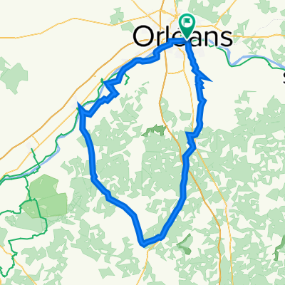
LOIRET -SO - 103KM
A cycling route starting in Saint-Jean-le-Blanc, Centre-Val de Loire, France.
Overview
About this route
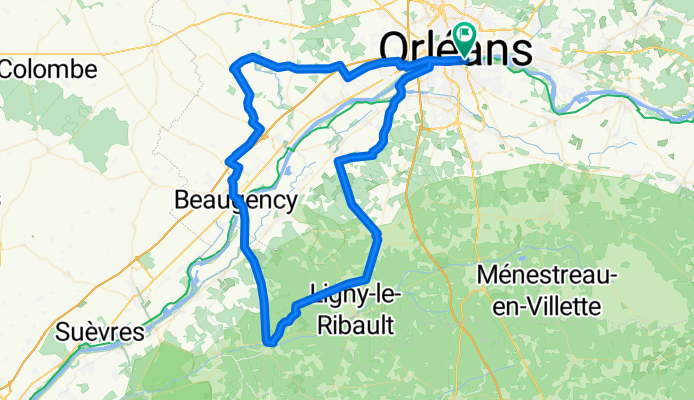
SO---103km---orléans-st privé-méziere- jouy- la Ferté St Cyr- PAUSE KM45.5 La Caillotière - beaugency -huisseau - chaingy - orléans.
A LIRE EN SENS INVERSE
- 6 h 19 min
- Duration
- 103.1 km
- Distance
- 280 m
- Ascent
- 278 m
- Descent
- 16.3 km/h
- Avg. speed
- 123 m
- Max. altitude
Route quality
Waytypes & surfaces along the route
Waytypes
Quiet road
30.9 km
(30 %)
Road
24.7 km
(24 %)
Surfaces
Paved
48.4 km
(47 %)
Asphalt
47.4 km
(46 %)
Concrete
1 km
(1 %)
Undefined
54.6 km
(53 %)
Route highlights
Points of interest along the route
Point of interest after 48.4 km
pause km 46
Continue with Bikemap
Use, edit, or download this cycling route
You would like to ride LOIRET -SO - 103KM or customize it for your own trip? Here is what you can do with this Bikemap route:
Free features
- Save this route as favorite or in collections
- Copy & plan your own version of this route
- Split it into stages to create a multi-day tour
- Sync your route with Garmin or Wahoo
Premium features
Free trial for 3 days, or one-time payment. More about Bikemap Premium.
- Navigate this route on iOS & Android
- Export a GPX / KML file of this route
- Create your custom printout (try it for free)
- Download this route for offline navigation
Discover more Premium features.
Get Bikemap PremiumFrom our community
Other popular routes starting in Saint-Jean-le-Blanc
LOIRET - SO - 92km orleans- Distance
- 91.6 km
- Ascent
- 226 m
- Descent
- 229 m
- Location
- Saint-Jean-le-Blanc, Centre-Val de Loire, France
LOIRET - SUD - 109km- Distance
- 109.1 km
- Ascent
- 332 m
- Descent
- 328 m
- Location
- Saint-Jean-le-Blanc, Centre-Val de Loire, France
LOIRET - S - 96KM - st privé-dry-moncay-lailly-huisseau-chaingy- Distance
- 95.4 km
- Ascent
- 298 m
- Descent
- 297 m
- Location
- Saint-Jean-le-Blanc, Centre-Val de Loire, France
LOIRET - SO - 82km orleans- Distance
- 80.7 km
- Ascent
- 189 m
- Descent
- 192 m
- Location
- Saint-Jean-le-Blanc, Centre-Val de Loire, France
LOIRET - SE -91km- Distance
- 91.1 km
- Ascent
- 356 m
- Descent
- 353 m
- Location
- Saint-Jean-le-Blanc, Centre-Val de Loire, France
LOIRET - N-EST-84km- Distance
- 83.4 km
- Ascent
- 352 m
- Descent
- 351 m
- Location
- Saint-Jean-le-Blanc, Centre-Val de Loire, France
LOIRET Ouest orleans, marchenoir 112km- Distance
- 113.6 km
- Ascent
- 648 m
- Descent
- 648 m
- Location
- Saint-Jean-le-Blanc, Centre-Val de Loire, France
LOIRET Nord - 117kms - Phithiviers le Viel- Distance
- 116.9 km
- Ascent
- 453 m
- Descent
- 453 m
- Location
- Saint-Jean-le-Blanc, Centre-Val de Loire, France
Open it in the app


