

Edenkobener Radpfad durch Forst bis Römische Wachstube von Hawai
A cycling route starting in Sankt Martin, Rhineland-Palatinate, Germany.
Overview
About this route
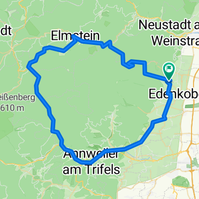
Beautiful. wide forest path around Edenkoben and St. Martin for MTB and X-Bike with tarmacked descent via the Totenkopfstr. The recording begins in Edenkoben at Werderberg. After a few hundred meters, the path passes the turnoff to the Peace Memorial on Werderberg itself. Then it goes steeply uphill to the St. Martin shelter and the Fronbaum hut, then to the Roman watchtower and descends past St. Martin Weyer back to Edenkoben. At a brisk pace, about 1 hour.
- -:--
- Duration
- 15.3 km
- Distance
- 284 m
- Ascent
- 453 m
- Descent
- ---
- Avg. speed
- ---
- Max. altitude
Continue with Bikemap
Use, edit, or download this cycling route
You would like to ride Edenkobener Radpfad durch Forst bis Römische Wachstube von Hawai or customize it for your own trip? Here is what you can do with this Bikemap route:
Free features
- Save this route as favorite or in collections
- Copy & plan your own version of this route
- Sync your route with Garmin or Wahoo
Premium features
Free trial for 3 days, or one-time payment. More about Bikemap Premium.
- Navigate this route on iOS & Android
- Export a GPX / KML file of this route
- Create your custom printout (try it for free)
- Download this route for offline navigation
Discover more Premium features.
Get Bikemap PremiumFrom our community
Other popular routes starting in Sankt Martin
 Hausrunde
- Distance
- 21.5 km
- Ascent
- 868 m
- Descent
- 868 m
- Location
- Sankt Martin, Rhineland-Palatinate, Germany
 Einfache Fahrt Totenkopfhütte
- Distance
- 2.8 km
- Ascent
- 76 m
- Descent
- 107 m
- Location
- Sankt Martin, Rhineland-Palatinate, Germany
 St Martin Ritt durch die Pfalz
- Distance
- 69 km
- Ascent
- 830 m
- Descent
- 834 m
- Location
- Sankt Martin, Rhineland-Palatinate, Germany
 20170325_Pfaelzer_Wald_Runde
- Distance
- 25.6 km
- Ascent
- 919 m
- Descent
- 919 m
- Location
- Sankt Martin, Rhineland-Palatinate, Germany
 Einmal um den Kalmit
- Distance
- 12.4 km
- Ascent
- 392 m
- Descent
- 392 m
- Location
- Sankt Martin, Rhineland-Palatinate, Germany
 Edenkobener Radpfad durch Forst bis Römische Wachstube von Hawai
- Distance
- 15.3 km
- Ascent
- 284 m
- Descent
- 453 m
- Location
- Sankt Martin, Rhineland-Palatinate, Germany
 05-MRZ-11
- Distance
- 13.5 km
- Ascent
- 561 m
- Descent
- 560 m
- Location
- Sankt Martin, Rhineland-Palatinate, Germany
 Pfälzer Wald Tour
- Distance
- 40 km
- Ascent
- 1,059 m
- Descent
- 1,026 m
- Location
- Sankt Martin, Rhineland-Palatinate, Germany
Open it in the app