
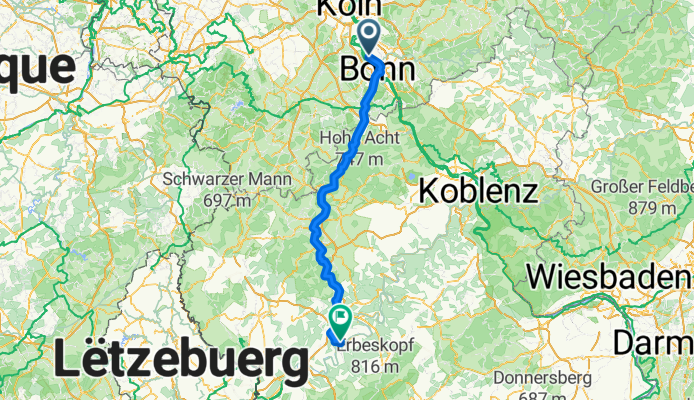
Rheidt Piesport Eifel
A cycling route starting in Niederkassel, North Rhine-Westphalia, Germany.
Overview
About this route
- 8 h 5 min
- Duration
- 140.6 km
- Distance
- 2,288 m
- Ascent
- 2,233 m
- Descent
- 17.4 km/h
- Avg. speed
- 582 m
- Avg. speed
Route quality
Waytypes & surfaces along the route
Waytypes
Road
22.7 km
(16 %)
Path
17 km
(12 %)
Surfaces
Paved
112.1 km
(80 %)
Unpaved
1.4 km
(<1 %)
Asphalt
108.4 km
(77 %)
Paved (undefined)
3.6 km
(3 %)
Continue with Bikemap
Use, edit, or download this cycling route
You would like to ride Rheidt Piesport Eifel or customize it for your own trip? Here is what you can do with this Bikemap route:
Free features
- Save this route as favorite or in collections
- Copy & plan your own version of this route
- Split it into stages to create a multi-day tour
- Sync your route with Garmin or Wahoo
Premium features
Free trial for 3 days, or one-time payment. More about Bikemap Premium.
- Navigate this route on iOS & Android
- Export a GPX / KML file of this route
- Create your custom printout (try it for free)
- Download this route for offline navigation
Discover more Premium features.
Get Bikemap PremiumFrom our community
Other popular routes starting in Niederkassel
 RTF LüRa neu 41km final
- Distance
- 41 km
- Ascent
- 35 m
- Descent
- 31 m
- Location
- Niederkassel, North Rhine-Westphalia, Germany
 LüRa RTF 2025 - 155km
- Distance
- 155.2 km
- Ascent
- 2,181 m
- Descent
- 2,180 m
- Location
- Niederkassel, North Rhine-Westphalia, Germany
 von Lülsdorf zum Geissbock
- Distance
- 42.8 km
- Ascent
- 70 m
- Descent
- 72 m
- Location
- Niederkassel, North Rhine-Westphalia, Germany
 Rheidt Piesport Eifel
- Distance
- 140.6 km
- Ascent
- 2,288 m
- Descent
- 2,233 m
- Location
- Niederkassel, North Rhine-Westphalia, Germany
 Siebengebirge 70km
- Distance
- 70.5 km
- Ascent
- 738 m
- Descent
- 737 m
- Location
- Niederkassel, North Rhine-Westphalia, Germany
 Hausroute
- Distance
- 19.8 km
- Ascent
- 15 m
- Descent
- 16 m
- Location
- Niederkassel, North Rhine-Westphalia, Germany
 Rhein/Bröl/Sieg
- Distance
- 82.5 km
- Ascent
- 932 m
- Descent
- 925 m
- Location
- Niederkassel, North Rhine-Westphalia, Germany
 Lülsdorf - Bundeshäuschen
- Distance
- 47.3 km
- Ascent
- 56 m
- Descent
- 53 m
- Location
- Niederkassel, North Rhine-Westphalia, Germany
Open it in the app