
Nationalparktour CH
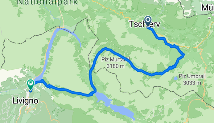
444-02: Nationalpark Bike-Tour. Etappe 2 Tschierv - Livigno
A cycling route starting in Scuol, Grisons, Switzerland.
Overview
About this route
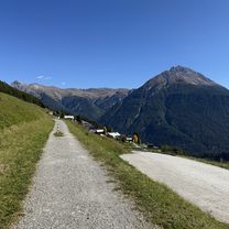
Vom Val Müstair durch das Val Vau hinauf zum Döss Radond (2234m) und weiter durch das Val Mora. Ab der Alp Mora (2220m) führt ein anspruchsvoller Singletrail zum Passo Val Mora (1952m). Nach dem Lago S. Giacomo di Fraéle (1949m) folgt der Anstieg zur Alpisella (2299m). Danach auf gutem Weg steil hinunter zum Lago di Livigno und nach Livigno (1810m).
- 3 h 12 min
- Duration
- 39.6 km
- Distance
- 1,467 m
- Ascent
- 1,324 m
- Descent
- 12.4 km/h
- Avg. speed
- 2,291 m
- Max. altitude

Part of
4 stages
Continue with Bikemap
Use, edit, or download this cycling route
You would like to ride 444-02: Nationalpark Bike-Tour. Etappe 2 Tschierv - Livigno or customize it for your own trip? Here is what you can do with this Bikemap route:
Free features
- Save this route as favorite or in collections
- Copy & plan your own version of this route
- Sync your route with Garmin or Wahoo
Premium features
Free trial for 3 days, or one-time payment. More about Bikemap Premium.
- Navigate this route on iOS & Android
- Export a GPX / KML file of this route
- Create your custom printout (try it for free)
- Download this route for offline navigation
Discover more Premium features.
Get Bikemap PremiumFrom our community
Other popular routes starting in Scuol
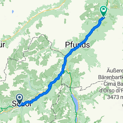 Scuol nach Ried im Oberinntal (Innradweg)
- Distance
- 46.9 km
- Ascent
- 1,107 m
- Descent
- 1,492 m
- Location
- Scuol, Grisons, Switzerland
 Brentschpark C, Scuol nach Stradun 327, Scuol
- Distance
- 35.8 km
- Ascent
- 1,029 m
- Descent
- 1,027 m
- Location
- Scuol, Grisons, Switzerland
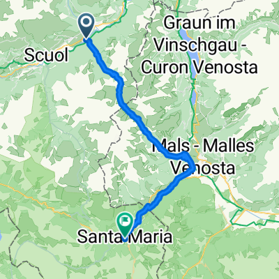 Transalp Etappe 4: Sur En - Santa Maria
- Distance
- 39.4 km
- Ascent
- 1,728 m
- Descent
- 1,483 m
- Location
- Scuol, Grisons, Switzerland
 De Stradun 317, Scuol a Vi 317, Scuol
- Distance
- 21.2 km
- Ascent
- 332 m
- Descent
- 369 m
- Location
- Scuol, Grisons, Switzerland
 TAC 2012 Etappe 5: Scuol-Livigno
- Distance
- 68 km
- Ascent
- 2,237 m
- Descent
- 1,570 m
- Location
- Scuol, Grisons, Switzerland
 Jakobsweg Graubünden, Scuol nach Vichava, Ftan
- Distance
- 40.8 km
- Ascent
- 1,495 m
- Descent
- 1,318 m
- Location
- Scuol, Grisons, Switzerland
 Uina Schlucht (Engadin)
- Distance
- 84.5 km
- Ascent
- 2,509 m
- Descent
- 2,509 m
- Location
- Scuol, Grisons, Switzerland
 Alpencross 2010 | Etappe 3
- Distance
- 73.7 km
- Ascent
- 2,522 m
- Descent
- 1,811 m
- Location
- Scuol, Grisons, Switzerland
Open it in the app