

Tatry 2012 - dzień 1
A cycling route starting in Gromnik, Lesser Poland Voivodeship, Poland.
Overview
About this route
1
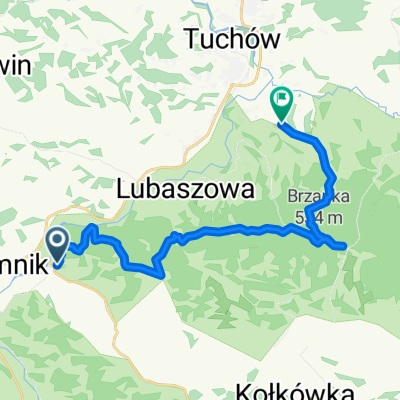
Trasa pierwszego dnia wypadu w tatry 2012. Dojazd do kwatery w Kościelisku.
- -:--
- Duration
- 179.7 km
- Distance
- 1,245 m
- Ascent
- 637 m
- Descent
- ---
- Avg. speed
- ---
- Max. altitude
krasu
created this 13 years ago
Route quality
Waytypes & surfaces along the route
Waytypes
Road
50.3 km
28 %
Quiet road
23.4 km
13 %
Surfaces
Paved
136.6 km
(76 %)
Unpaved
5.4 km
(3 %)
Asphalt
127.6 km
71 %
Concrete
5.4 km
3 %
Continue with Bikemap
Use, edit, or download this cycling route
You would like to ride Tatry 2012 - dzień 1 or customize it for your own trip? Here is what you can do with this Bikemap route:
Free features
- Save this route as favorite or in collections
- Copy & plan your own version of this route
- Split it into stages to create a multi-day tour
- Sync your route with Garmin or Wahoo
Premium features
Free trial for 3 days, or one-time payment. More about Bikemap Premium.
- Navigate this route on iOS & Android
- Export a GPX / KML file of this route
- Create your custom printout (try it for free)
- Download this route for offline navigation
Discover more Premium features.
Get Bikemap PremiumFrom our community
Other popular routes starting in Gromnik
- Jana Pawła II 1, Gromnik do Pogórze 9, Gromnik0
- 38.9 km
- 759 m
- 754 m
- Gromnik, Lesser Poland Voivodeship, Poland


Open it in the app