
Check-in to Flughafenstraße
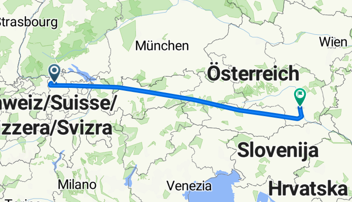
A cycling route starting in Kloten / Holberg, Canton of Zurich, Switzerland.
Overview
About this route
- 1 h 7 min
- Duration
- 574.9 km
- Distance
- 7,691 m
- Ascent
- 7,854 m
- Descent
- 513.7 km/h
- Avg. speed
- 8,115 m
- Max. altitude

Route photos


Continue with Bikemap
Use, edit, or download this cycling route
You would like to ride Check-in to Flughafenstraße or customize it for your own trip? Here is what you can do with this Bikemap route:
Free features
- Save this route as favorite or in collections
- Copy & plan your own version of this route
- Split it into stages to create a multi-day tour
- Sync your route with Garmin or Wahoo
Premium features
Free trial for 3 days, or one-time payment. More about Bikemap Premium.
- Navigate this route on iOS & Android
- Export a GPX / KML file of this route
- Create your custom printout (try it for free)
- Download this route for offline navigation
Discover more Premium features.
Get Bikemap PremiumFrom our community
Other popular routes starting in Kloten / Holberg
 Frachtstrasse to Salzkottener Straße
- Distance
- 797.7 km
- Ascent
- 11,746 m
- Descent
- 12,103 m
- Location
- Kloten / Holberg, Canton of Zurich, Switzerland
 Flughafenstrasse 79, Kloten nach Roswiesstrasse 3, Zollikerberg
- Distance
- 18.2 km
- Ascent
- 333 m
- Descent
- 164 m
- Location
- Kloten / Holberg, Canton of Zurich, Switzerland
 Flughafenstrasse to Flughafenstraße
- Distance
- 569 km
- Ascent
- 9,237 m
- Descent
- 10,364 m
- Location
- Kloten / Holberg, Canton of Zurich, Switzerland
 Vorfahrt Abflug, Kloten to Marktplatz 8–10, Basel
- Distance
- 96 km
- Ascent
- 736 m
- Descent
- 910 m
- Location
- Kloten / Holberg, Canton of Zurich, Switzerland
 Zurich to Bormio via Davos
- Distance
- 261.1 km
- Ascent
- 3,841 m
- Descent
- 3,063 m
- Location
- Kloten / Holberg, Canton of Zurich, Switzerland
 Vorfahrt Abflug, Kloten to Bahnhofstrasse 13, Stein am Rhein
- Distance
- 49.9 km
- Ascent
- 556 m
- Descent
- 585 m
- Location
- Kloten / Holberg, Canton of Zurich, Switzerland
 Kloten - Otelfingen - Bülach - Kloten
- Distance
- 54.3 km
- Ascent
- 500 m
- Descent
- 502 m
- Location
- Kloten / Holberg, Canton of Zurich, Switzerland
- Check-in to Flughafenstraße
- Distance
- 574.9 km
- Ascent
- 7,691 m
- Descent
- 7,854 m
- Location
- Kloten / Holberg, Canton of Zurich, Switzerland
Open it in the app