

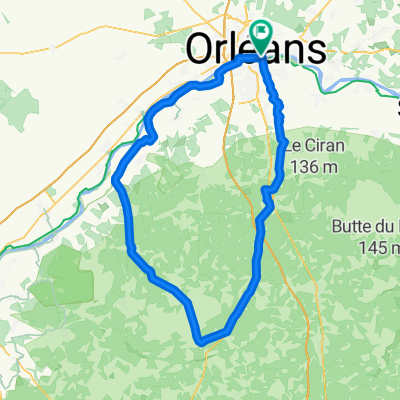
LOIRET - SUD - 109km
A cycling route starting in Saint-Jean-le-Blanc, Centre-Val de Loire, France.
Overview
About this route
south of orléans 109 km - saint-cyr via cycle path - la ferté (via ZI road) - chaumont-sur-tharonne - (PAUSE KM 44 Le Grand Soupeau) - la ferté-beauharnais - neung-sur-beuvron - la marolle - la ferté-saint-cyr - beaugency - dry - meung - return along the levée de la Loire
- 6 h 22 min
- Duration
- 109.1 km
- Distance
- 332 m
- Ascent
- 328 m
- Descent
- 17.1 km/h
- Avg. speed
- 146 m
- Max. altitude

Route quality
Waytypes & surfaces along the route
Waytypes
Quiet road
42.5 km
(39 %)
Road
10.9 km
(10 %)
Surfaces
Paved
50.2 km
(46 %)
Unpaved
1.1 km
(1 %)
Asphalt
50.2 km
(46 %)
Ground
1.1 km
(1 %)
Undefined
57.8 km
(53 %)
Continue with Bikemap
Use, edit, or download this cycling route
You would like to ride LOIRET - SUD - 109km or customize it for your own trip? Here is what you can do with this Bikemap route:
Free features
- Save this route as favorite or in collections
- Copy & plan your own version of this route
- Split it into stages to create a multi-day tour
- Sync your route with Garmin or Wahoo
Premium features
Free trial for 3 days, or one-time payment. More about Bikemap Premium.
- Navigate this route on iOS & Android
- Export a GPX / KML file of this route
- Create your custom printout (try it for free)
- Download this route for offline navigation
Discover more Premium features.
Get Bikemap PremiumFrom our community
Other popular routes starting in Saint-Jean-le-Blanc
 LOIRET - SO - 82km orleans
- Distance
- 80.7 km
- Ascent
- 189 m
- Descent
- 192 m
- Location
- Saint-Jean-le-Blanc, Centre-Val de Loire, France
 LOIRET Nord - 117kms - Phithiviers le Viel
- Distance
- 116.9 km
- Ascent
- 453 m
- Descent
- 453 m
- Location
- Saint-Jean-le-Blanc, Centre-Val de Loire, France
 LOIRET NE - 111 KMS - étang de la vallée- chambon
- Distance
- 111.5 km
- Ascent
- 157 m
- Descent
- 157 m
- Location
- Saint-Jean-le-Blanc, Centre-Val de Loire, France
 LOIRET - N-EST-84km
- Distance
- 83.4 km
- Ascent
- 352 m
- Descent
- 351 m
- Location
- Saint-Jean-le-Blanc, Centre-Val de Loire, France
 LOIRET - SUD - 109km
- Distance
- 109.1 km
- Ascent
- 332 m
- Descent
- 328 m
- Location
- Saint-Jean-le-Blanc, Centre-Val de Loire, France
 LOIRET - SO - 92km orleans
- Distance
- 91.6 km
- Ascent
- 226 m
- Descent
- 229 m
- Location
- Saint-Jean-le-Blanc, Centre-Val de Loire, France
 LOIRET SO -110KM saran - gidy - beaugency
- Distance
- 109.8 km
- Ascent
- 262 m
- Descent
- 259 m
- Location
- Saint-Jean-le-Blanc, Centre-Val de Loire, France
 LOIRET Ouest orleans, marchenoir 112km
- Distance
- 113.6 km
- Ascent
- 648 m
- Descent
- 648 m
- Location
- Saint-Jean-le-Blanc, Centre-Val de Loire, France
Open it in the app