

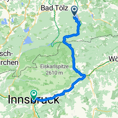
Schinderrunde Tegernsee
A cycling route starting in Bad Wiessee, Bavaria, Germany.
Overview
About this route
- -:--
- Duration
- 59 km
- Distance
- 1,195 m
- Ascent
- 1,195 m
- Descent
- ---
- Avg. speed
- ---
- Max. altitude
Continue with Bikemap
Use, edit, or download this cycling route
You would like to ride Schinderrunde Tegernsee or customize it for your own trip? Here is what you can do with this Bikemap route:
Free features
- Save this route as favorite or in collections
- Copy & plan your own version of this route
- Sync your route with Garmin or Wahoo
Premium features
Free trial for 3 days, or one-time payment. More about Bikemap Premium.
- Navigate this route on iOS & Android
- Export a GPX / KML file of this route
- Create your custom printout (try it for free)
- Download this route for offline navigation
Discover more Premium features.
Get Bikemap PremiumFrom our community
Other popular routes starting in Bad Wiessee
 T20_Hirschberg
- Distance
- 40.1 km
- Ascent
- 1,160 m
- Descent
- 1,160 m
- Location
- Bad Wiessee, Bavaria, Germany
 20090726 Schinderrunde
- Distance
- 62.4 km
- Ascent
- 977 m
- Descent
- 989 m
- Location
- Bad Wiessee, Bavaria, Germany
 hirschbergtrail-bad-wiessee
- Distance
- 24.6 km
- Ascent
- 684 m
- Descent
- 683 m
- Location
- Bad Wiessee, Bavaria, Germany
 Bad-Wiesee-Gindelalm-Bad Wiesee
- Distance
- 32.2 km
- Ascent
- 868 m
- Descent
- 868 m
- Location
- Bad Wiessee, Bavaria, Germany
 Um den Hirschberg
- Distance
- 27.9 km
- Ascent
- 365 m
- Descent
- 365 m
- Location
- Bad Wiessee, Bavaria, Germany
 Schwarze Tenn - Runde
- Distance
- 28.1 km
- Ascent
- 386 m
- Descent
- 386 m
- Location
- Bad Wiessee, Bavaria, Germany
 Transalp 2009
- Distance
- 415.3 km
- Ascent
- 7,144 m
- Descent
- 7,816 m
- Location
- Bad Wiessee, Bavaria, Germany
 Bad Heilbrunn - Bad Wiessee + Von Bad Wiessee bis Vahrn
- Distance
- 101.7 km
- Ascent
- 1,551 m
- Descent
- 1,716 m
- Location
- Bad Wiessee, Bavaria, Germany
Open it in the app