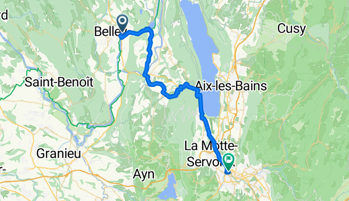
Belley to Chambéry
A cycling route starting in Belley, Auvergne-RhĂ´ne-Alpes, France.
Overview
About this route
Great ride through some beautiful countryside. Missed a turn that put us back on D1504 at St-Jean-de-Chevelu, but that was probably an easier climb to the bicycle Tunnel du Chat. And the paved bicycle path along the lake and into Chambéry was excellent.
- 24 h 36 min
- Duration
- 42.9 km
- Distance
- 697 m
- Ascent
- 673 m
- Descent
- 1.7 km/h
- Avg. speed
- 488 m
- Max. altitude
Route photos
Route quality
Waytypes & surfaces along the route
Waytypes
Road
15.9 km
(37 %)
Cycleway
14.6 km
(34 %)
Surfaces
Paved
27.9 km
(65 %)
Unpaved
0.9 km
(2 %)
Asphalt
26.6 km
(62 %)
Concrete
1.3 km
(3 %)
Continue with Bikemap
Use, edit, or download this cycling route
You would like to ride Belley to Chambéry or customize it for your own trip? Here is what you can do with this Bikemap route:
Free features
- Save this route as favorite or in collections
- Copy & plan your own version of this route
- Sync your route with Garmin or Wahoo
Premium features
Free trial for 3 days, or one-time payment. More about Bikemap Premium.
- Navigate this route on iOS & Android
- Export a GPX / KML file of this route
- Create your custom printout (try it for free)
- Download this route for offline navigation
Discover more Premium features.
Get Bikemap PremiumFrom our community
Other popular routes starting in Belley
- étape 4 jours 1
- Distance
- 27.9 km
- Ascent
- 376 m
- Descent
- 390 m
- Location
- Belley, Auvergne-RhĂ´ne-Alpes, France
- EU 32 _ Belley - Genf _ 93 km
- Distance
- 94.1 km
- Ascent
- 658 m
- Descent
- 539 m
- Location
- Belley, Auvergne-RhĂ´ne-Alpes, France
- Izieux par la viarhona
- Distance
- 52.3 km
- Ascent
- 614 m
- Descent
- 614 m
- Location
- Belley, Auvergne-RhĂ´ne-Alpes, France
- Belley to Chambéry
- Distance
- 42.9 km
- Ascent
- 697 m
- Descent
- 673 m
- Location
- Belley, Auvergne-RhĂ´ne-Alpes, France
- von Genf nach Lyon - Tag 4 - von Belley nach Saint-Victor de Morestel
- Distance
- 43.5 km
- Ascent
- 172 m
- Descent
- 212 m
- Location
- Belley, Auvergne-RhĂ´ne-Alpes, France
- Chanaz-Grenoble
- Distance
- 127.7 km
- Ascent
- 1,926 m
- Descent
- 1,948 m
- Location
- Belley, Auvergne-RhĂ´ne-Alpes, France
- Chanaz - Lac du Bourget
- Distance
- 45.3 km
- Ascent
- 623 m
- Descent
- 622 m
- Location
- Belley, Auvergne-RhĂ´ne-Alpes, France
- Coron to Les Granges
- Distance
- 44 km
- Ascent
- 238 m
- Descent
- 245 m
- Location
- Belley, Auvergne-RhĂ´ne-Alpes, France
Open it in the app