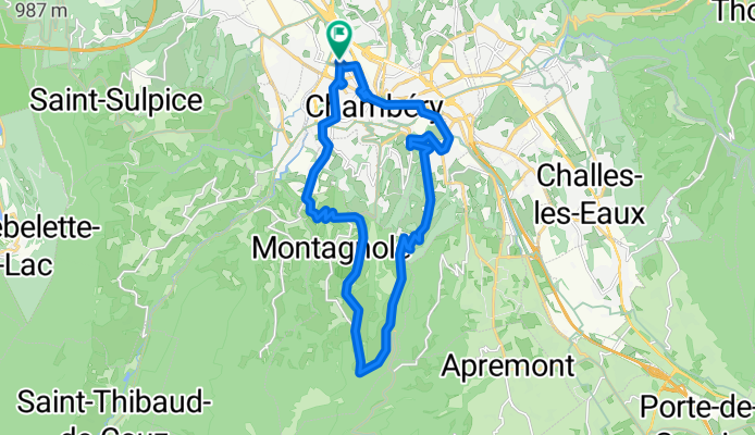
- 47.2 km
- 870 m
- 938 m
- Cognin, Auvergne-RhĂ´ne-Alpes, France
Chambéry - Circle toward Col du Granier
A cycling route starting in Cognin, Auvergne-RhĂ´ne-Alpes, France.
Overview
About this route
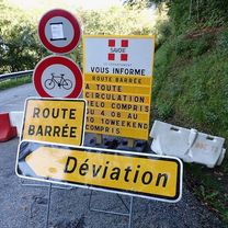
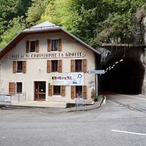
This was a short abbreviated ride due to the tunnel closure on D912. Our original intention was to ride to St-Pierre-d'Entremont and then west on D520c before circlling back to Chambéry on D1006. For anyone wanting a shorter ride with plenty of climbing and wonderful scenery, this route is great.
- 22 h 56 min
- Duration
- 23.4 km
- Distance
- 670 m
- Ascent
- 673 m
- Descent
- 1 km/h
- Avg. speed
- 718 m
- Max. altitude
created this 2 months ago
Route photos
Route quality
Waytypes & surfaces along the route
Waytypes
Road
11.9 km
(51 %)
Cycleway
1.6 km
(7 %)
Surfaces
Paved
18.2 km
(78 %)
Unpaved
0.2 km
(1 %)
Asphalt
18.2 km
(78 %)
Loose gravel
0.2 km
(1 %)
Undefined
4.9 km
(21 %)
Continue with Bikemap
Use, edit, or download this cycling route
You would like to ride Chambéry - Circle toward Col du Granier or customize it for your own trip? Here is what you can do with this Bikemap route:
Free features
- Save this route as favorite or in collections
- Copy & plan your own version of this route
- Sync your route with Garmin or Wahoo
Premium features
Free trial for 3 days, or one-time payment. More about Bikemap Premium.
- Navigate this route on iOS & Android
- Export a GPX / KML file of this route
- Create your custom printout (try it for free)
- Download this route for offline navigation
Discover more Premium features.
Get Bikemap PremiumFrom our community
Other popular routes starting in Cognin
- Chambéry to Voreppe
- Granier - col des Egaux
- 53.4 km
- 1,326 m
- 1,325 m
- Cognin, Auvergne-RhĂ´ne-Alpes, France
- VTT SAINT SULPICE
- 27.1 km
- 0 m
- 0 m
- Cognin, Auvergne-RhĂ´ne-Alpes, France
- granier via st baldoph et pas de la fosse
- 17.9 km
- 923 m
- 57 m
- Cognin, Auvergne-RhĂ´ne-Alpes, France
- Tour de lac
- 72 km
- 956 m
- 958 m
- Cognin, Auvergne-RhĂ´ne-Alpes, France
- STB_Barca_act_007_0811_Chambery - Valence
- 130.1 km
- 716 m
- 881 m
- Cognin, Auvergne-RhĂ´ne-Alpes, France
- Chambéry - Circle toward Col du Granier
- 23.4 km
- 670 m
- 673 m
- Cognin, Auvergne-RhĂ´ne-Alpes, France
- bauges VTT
- 591.1 km
- 7,630 m
- 7,559 m
- Cognin, Auvergne-RhĂ´ne-Alpes, France
Open it in the app


