Chambéry to Voreppe
A cycling route starting in Cognin, Auvergne-RhĂ´ne-Alpes, France.
Overview
About this route
Overall, this was a great ride. D1006 had traffic, but it had a lot of good shoulder. I think only the section from St-Thibaud-de-Couz to Les Gros Louis was without road shoulder. Note that there's shoulder on the long climb out of Chambéry going southwest, but there's no shoulder on the descent going northeast toward Chambéry from the Col de Couz. The climb was pretty gradual with nothing too steep.
Later in the ride along the small country road Chemin de la Bourderie, there were some steeper inclines, and one very steep decline on the Chemin des Roux.
After getting to the Col de la Placette at 588M, there was a very long descent into Voreppe.
Overall, some very nice scenery. We highly recommend this ride.
- 24 h 40 min
- Duration
- 47.2 km
- Distance
- 870 m
- Ascent
- 938 m
- Descent
- 1.9 km/h
- Avg. speed
- 628 m
- Max. altitude
Route photos
Route quality
Waytypes & surfaces along the route
Waytypes
Road
8.5 km
(18 %)
Quiet road
7.1 km
(15 %)
Surfaces
Paved
31.2 km
(66 %)
Asphalt
30.2 km
(64 %)
Paved (undefined)
0.9 km
(2 %)
Undefined
16 km
(34 %)
Continue with Bikemap
Use, edit, or download this cycling route
You would like to ride Chambéry to Voreppe or customize it for your own trip? Here is what you can do with this Bikemap route:
Free features
- Save this route as favorite or in collections
- Copy & plan your own version of this route
- Sync your route with Garmin or Wahoo
Premium features
Free trial for 3 days, or one-time payment. More about Bikemap Premium.
- Navigate this route on iOS & Android
- Export a GPX / KML file of this route
- Create your custom printout (try it for free)
- Download this route for offline navigation
Discover more Premium features.
Get Bikemap PremiumFrom our community
Other popular routes starting in Cognin
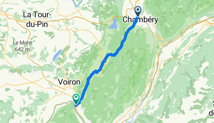
- STB_Barca_act_007_0811_Chambery - Valence
- Distance
- 130.1 km
- Ascent
- 716 m
- Descent
- 881 m
- Location
- Cognin, Auvergne-RhĂ´ne-Alpes, France
- Chambéry - Circle toward Col du Granier
- Distance
- 23.4 km
- Ascent
- 670 m
- Descent
- 673 m
- Location
- Cognin, Auvergne-RhĂ´ne-Alpes, France
- jarrier bidob
- Distance
- 11.8 km
- Ascent
- 76 m
- Descent
- 47 m
- Location
- Cognin, Auvergne-RhĂ´ne-Alpes, France
- bauges VTT
- Distance
- 591.1 km
- Ascent
- 7,630 m
- Descent
- 7,559 m
- Location
- Cognin, Auvergne-RhĂ´ne-Alpes, France
- granier via st baldoph et pas de la fosse
- Distance
- 17.9 km
- Ascent
- 923 m
- Descent
- 57 m
- Location
- Cognin, Auvergne-RhĂ´ne-Alpes, France
- Road to perdiyio
- Distance
- 82.9 km
- Ascent
- 1,909 m
- Descent
- 2,044 m
- Location
- Cognin, Auvergne-RhĂ´ne-Alpes, France
- Tour de lac
- Distance
- 72 km
- Ascent
- 956 m
- Descent
- 958 m
- Location
- Cognin, Auvergne-RhĂ´ne-Alpes, France
- 4 COLS CHARTREUSE 24/03/2015
- Distance
- 57.8 km
- Ascent
- 1,479 m
- Descent
- 1,477 m
- Location
- Cognin, Auvergne-RhĂ´ne-Alpes, France
Open it in the app