
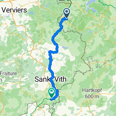
Von Wasserbillig bis Aachen
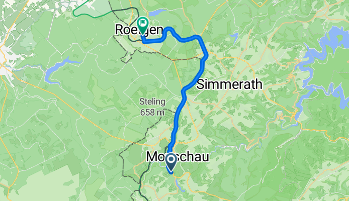
Camping Monschau - Camping Roetgen
A cycling route starting in Monschau, North Rhine-Westphalia, Germany.
Overview
About this route
- 1 h 16 min
- Duration
- 19.7 km
- Distance
- 179 m
- Ascent
- 198 m
- Descent
- 15.5 km/h
- Avg. speed
- 554 m
- Max. altitude

Part of
Von Wasserbillig bis Aachen
8 stages
Route quality
Waytypes & surfaces along the route
Waytypes
Path
11 km
(56 %)
Cycleway
6.9 km
(35 %)
Surfaces
Paved
17 km
(86 %)
Unpaved
0.2 km
(1 %)
Asphalt
17 km
(86 %)
Ground
0.2 km
(1 %)
Undefined
2.6 km
(13 %)
Continue with Bikemap
Use, edit, or download this cycling route
You would like to ride Camping Monschau - Camping Roetgen or customize it for your own trip? Here is what you can do with this Bikemap route:
Free features
- Save this route as favorite or in collections
- Copy & plan your own version of this route
- Sync your route with Garmin or Wahoo
Premium features
Free trial for 3 days, or one-time payment. More about Bikemap Premium.
- Navigate this route on iOS & Android
- Export a GPX / KML file of this route
- Create your custom printout (try it for free)
- Download this route for offline navigation
Discover more Premium features.
Get Bikemap PremiumFrom our community
Other popular routes starting in Monschau
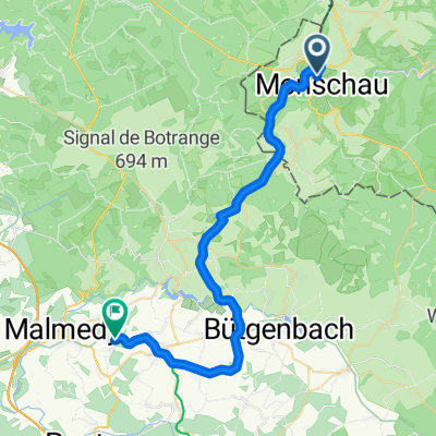 VB 3 - Monschau (D) - Arimont (B, Waimes) 34 km
- Distance
- 33.6 km
- Ascent
- 386 m
- Descent
- 363 m
- Location
- Monschau, North Rhine-Westphalia, Germany
 Grünentalstraße nach Grünentalstraße
- Distance
- 7.8 km
- Ascent
- 152 m
- Descent
- 151 m
- Location
- Monschau, North Rhine-Westphalia, Germany
 Hilgershof nach Eschbachstraße
- Distance
- 2.1 km
- Ascent
- 18 m
- Descent
- 119 m
- Location
- Monschau, North Rhine-Westphalia, Germany
 Vichtbachtal Hohes-Venn
- Distance
- 55.6 km
- Ascent
- 259 m
- Descent
- 592 m
- Location
- Monschau, North Rhine-Westphalia, Germany
 Monschau - Burg-Reuland über Vennbahn-Radweg
- Distance
- 61.9 km
- Ascent
- 652 m
- Descent
- 687 m
- Location
- Monschau, North Rhine-Westphalia, Germany
 Camping Monschau - Camping Roetgen
- Distance
- 19.7 km
- Ascent
- 179 m
- Descent
- 198 m
- Location
- Monschau, North Rhine-Westphalia, Germany
 Stadtstraße nach Aachen
- Distance
- 53.7 km
- Ascent
- 180 m
- Descent
- 471 m
- Location
- Monschau, North Rhine-Westphalia, Germany
 große Waldrunde
- Distance
- 28.7 km
- Ascent
- 372 m
- Descent
- 372 m
- Location
- Monschau, North Rhine-Westphalia, Germany
Open it in the app