
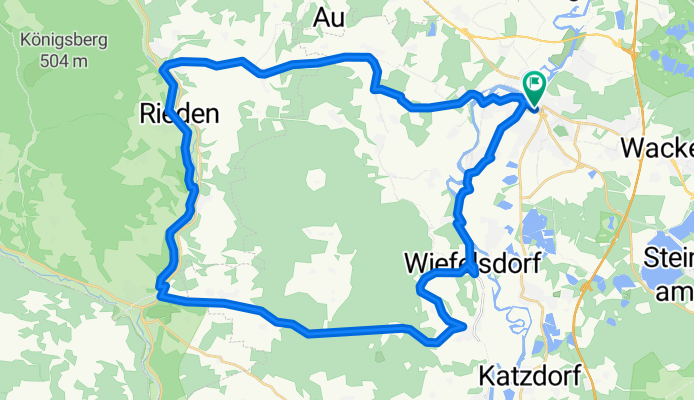
ADFC SAD-Schmidmühlen-Ensdorf-SAD 47
A cycling route starting in Schwandorf in Bayern, Bavaria, Germany.
Overview
About this route
Rideable via Sitzenhof/Horsch on weekends. Station SAD
- 3 h 21 min
- Duration
- 46.5 km
- Distance
- 916 m
- Ascent
- 914 m
- Descent
- 13.9 km/h
- Avg. speed
- 476 m
- Max. altitude
Continue with Bikemap
Use, edit, or download this cycling route
You would like to ride ADFC SAD-Schmidmühlen-Ensdorf-SAD 47 or customize it for your own trip? Here is what you can do with this Bikemap route:
Free features
- Save this route as favorite or in collections
- Copy & plan your own version of this route
- Sync your route with Garmin or Wahoo
Premium features
Free trial for 3 days, or one-time payment. More about Bikemap Premium.
- Navigate this route on iOS & Android
- Export a GPX / KML file of this route
- Create your custom printout (try it for free)
- Download this route for offline navigation
Discover more Premium features.
Get Bikemap PremiumFrom our community
Other popular routes starting in Schwandorf in Bayern
 Zur Alten Hochstraße
- Distance
- 19.4 km
- Ascent
- 207 m
- Descent
- 207 m
- Location
- Schwandorf in Bayern, Bavaria, Germany
 Tour nach Bad Abbach endlang der Donau
- Distance
- 89.4 km
- Ascent
- 1,045 m
- Descent
- 1,045 m
- Location
- Schwandorf in Bayern, Bavaria, Germany
 Kallmünz übers Vilstal
- Distance
- 57.9 km
- Ascent
- 330 m
- Descent
- 333 m
- Location
- Schwandorf in Bayern, Bavaria, Germany
 Otto-Hahn-Straße nach Naabgasse
- Distance
- 16.2 km
- Ascent
- 93 m
- Descent
- 124 m
- Location
- Schwandorf in Bayern, Bavaria, Germany
 Kallmünz übers Vilstal
- Distance
- 57.9 km
- Ascent
- 340 m
- Descent
- 343 m
- Location
- Schwandorf in Bayern, Bavaria, Germany
 Rund um Naabeck
- Distance
- 18.7 km
- Ascent
- 159 m
- Descent
- 159 m
- Location
- Schwandorf in Bayern, Bavaria, Germany
 Angerring 35, Schwandorf nach Angerring 34, Schwandorf
- Distance
- 17.4 km
- Ascent
- 199 m
- Descent
- 198 m
- Location
- Schwandorf in Bayern, Bavaria, Germany
 Bahnhof/ZOB nach Bahnhof/ZOB
- Distance
- 58.5 km
- Ascent
- 177 m
- Descent
- 178 m
- Location
- Schwandorf in Bayern, Bavaria, Germany
Open it in the app