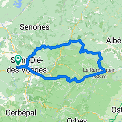
2012 French Tour -- Ride Day 19 -- 27 August 2012 -- St-Dié-des-Vosges -- Circle
A cycling route starting in Saint-Dié, Grand Est, France.
Overview
About this route
To be adde later...
All rouds were outstanding low traffic roads.
Note that there's one section of a few kilometers that is unpacked, but was barely OK for our 700x35 tires. Â Also, the small badly paved section just before the unsaved portion must have been 15% or 20% at least. Â Ride this portion only if you are very adventurous.
- -:--
- Duration
- 88.2 km
- Distance
- 939 m
- Ascent
- 939 m
- Descent
- ---
- Avg. speed
- ---
- Max. altitude
Route quality
Waytypes & surfaces along the route
Waytypes
Road
20.3 km
(23 %)
Quiet road
11.5 km
(13 %)
Surfaces
Paved
36.2 km
(41 %)
Unpaved
7.1 km
(8 %)
Asphalt
36.2 km
(41 %)
Gravel
7.1 km
(8 %)
Undefined
45 km
(51 %)
Continue with Bikemap
Use, edit, or download this cycling route
You would like to ride 2012 French Tour -- Ride Day 19 -- 27 August 2012 -- St-Dié-des-Vosges -- Circle or customize it for your own trip? Here is what you can do with this Bikemap route:
Free features
- Save this route as favorite or in collections
- Copy & plan your own version of this route
- Split it into stages to create a multi-day tour
- Sync your route with Garmin or Wahoo
Premium features
Free trial for 3 days, or one-time payment. More about Bikemap Premium.
- Navigate this route on iOS & Android
- Export a GPX / KML file of this route
- Create your custom printout (try it for free)
- Download this route for offline navigation
Discover more Premium features.
Get Bikemap PremiumFrom our community
Other popular routes starting in Saint-Dié
2012 French Tour -- Ride Day 19 -- 27 August 2012 -- St-Dié-des-Vosges -- Circle- Distance
- 88.2 km
- Ascent
- 939 m
- Descent
- 939 m
- Location
- Saint-Dié, Grand Est, France
Randonnée en Vosges et Alsace.- Distance
- 138.8 km
- Ascent
- 1,916 m
- Descent
- 1,907 m
- Location
- Saint-Dié, Grand Est, France
Saint Dié ex J05- Distance
- 71.7 km
- Ascent
- 919 m
- Descent
- 928 m
- Location
- Saint-Dié, Grand Est, France
Stage 1 Europa's Ziekste ALT- Distance
- 155.4 km
- Ascent
- 2,103 m
- Descent
- 1,987 m
- Location
- Saint-Dié, Grand Est, France
Vogesen Route- Distance
- 219.9 km
- Ascent
- 4,883 m
- Descent
- 3,888 m
- Location
- Saint-Dié, Grand Est, France
de saint dié à remirement via gerardmer- Distance
- 61.6 km
- Ascent
- 676 m
- Descent
- 631 m
- Location
- Saint-Dié, Grand Est, France
2012 French Tour -- Ride Day 20 -- 28 August 2012 -- St-Dié-des-Vosges -- Circle- Distance
- 31.4 km
- Ascent
- 439 m
- Descent
- 439 m
- Location
- Saint-Dié, Grand Est, France
2007-10-13 Saint Dié- Distance
- 45.2 km
- Ascent
- 1,013 m
- Descent
- 1,013 m
- Location
- Saint-Dié, Grand Est, France
Open it in the app


