

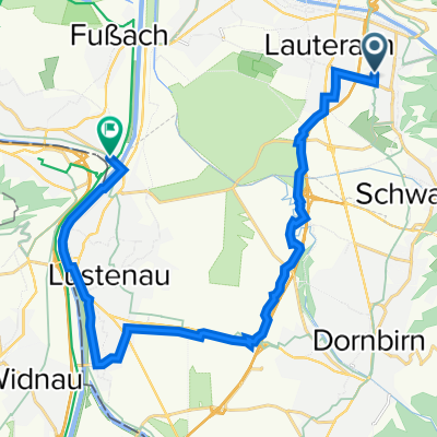
Route in Wolfurt
A cycling route starting in Wolfurt, Vorarlberg, Austria.
Overview
About this route
0
- 3:41 h
- Duration
- 66.3 km
- Distance
- 173 m
- Ascent
- 175 m
- Descent
- 18 km/h
- Avg. speed
- 447 m
- Max. altitude
August Rohner
created this 3 months ago
Route quality
Waytypes & surfaces along the route
Waytypes
Quiet road
32.5 km
49 %
Cycleway
15.2 km
23 %
Surfaces
Paved
65.6 km
(99 %)
Asphalt
65.6 km
99 %
Undefined
0.7 km
1 %
Continue with Bikemap
Use, edit, or download this cycling route
You would like to ride Route in Wolfurt or customize it for your own trip? Here is what you can do with this Bikemap route:
Free features
- Save this route as favorite or in collections
- Copy & plan your own version of this route
- Sync your route with Garmin or Wahoo
Premium features
Free trial for 3 days, or one-time payment. More about Bikemap Premium.
- Navigate this route on iOS & Android
- Export a GPX / KML file of this route
- Create your custom printout (try it for free)
- Download this route for offline navigation
Discover more Premium features.
Get Bikemap PremiumFrom our community
Other popular routes starting in Wolfurt
- Schmerzenbildstraße, Wolfurt nach Schmerzenbildstraße, Wolfurt0
- 30.7 km
- 75 m
- 74 m
- Wolfurt, Vorarlberg, Austria
- Schmerzenbildstraße 42, Wolfurt nach Oberer Achdamm 27, Hard0
- 3.9 km
- 13 m
- 16 m
- Wolfurt, Vorarlberg, Austria
- Schmerzenbildstraße 44a, Wolfurt nach Brugger Straße 79, Höchst0
- 19.9 km
- 40 m
- 48 m
- Wolfurt, Vorarlberg, Austria


Open it in the app