

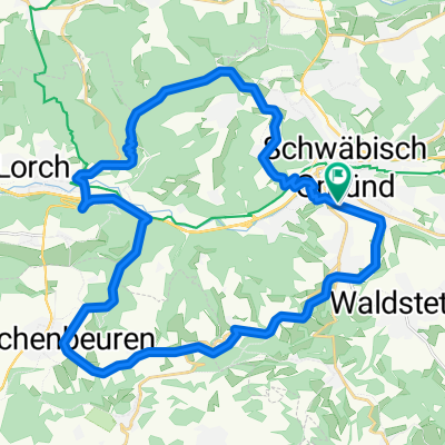
Schwäbisch Gmünd - Holzheim
A cycling route starting in Schwäbisch Gmünd, Baden-Wurttemberg, Germany.
Overview
About this route
0
- 4:51 h
- Duration
- 83.7 km
- Distance
- 1,055 m
- Ascent
- 987 m
- Descent
- 17.3 km/h
- Avg. speed
- 706 m
- Max. altitude
Shawn Johnson
created this 20 days ago
Route quality
Waytypes & surfaces along the route
Waytypes
Track
27.6 km
33 %
Path
27.6 km
33 %
Surfaces
Paved
74.5 km
(89 %)
Asphalt
70.3 km
84 %
Paved (undefined)
4.2 km
5 %
Undefined
9.2 km
11 %
Continue with Bikemap
Use, edit, or download this cycling route
You would like to ride Schwäbisch Gmünd - Holzheim or customize it for your own trip? Here is what you can do with this Bikemap route:
Free features
- Save this route as favorite or in collections
- Copy & plan your own version of this route
- Split it into stages to create a multi-day tour
- Sync your route with Garmin or Wahoo
Premium features
Free trial for 3 days, or one-time payment. More about Bikemap Premium.
- Navigate this route on iOS & Android
- Export a GPX / KML file of this route
- Create your custom printout (try it for free)
- Download this route for offline navigation
Discover more Premium features.
Get Bikemap PremiumFrom our community
Other popular routes starting in Schwäbisch Gmünd
- Gmünd-Wäschenbeuren-Lorch-Haselbachtal-Himmel2
- 34.4 km
- 423 m
- 428 m
- Schwäbisch Gmünd, Baden-Wurttemberg, Germany
- Schindelackerweg, Schwäbisch Gmünd nach Mittelbachstraße, Aalen0
- 26.1 km
- 364 m
- 263 m
- Schwäbisch Gmünd, Baden-Wurttemberg, Germany
- Gmünd - Dehner - Aasrücken - Wäscherschloss - Gmünd2
- 30.3 km
- 480 m
- 480 m
- Schwäbisch Gmünd, Baden-Wurttemberg, Germany
- Parlerstraße 34/1 nach Gottlieb-Daimler-Straße0
- 4.6 km
- 87 m
- 43 m
- Schwäbisch Gmünd, Baden-Wurttemberg, Germany
- Schwäbisch Gmünd - Steinheim an der Murr0
- 55.4 km
- 525 m
- 650 m
- Schwäbisch Gmünd, Baden-Wurttemberg, Germany


Open it in the app