


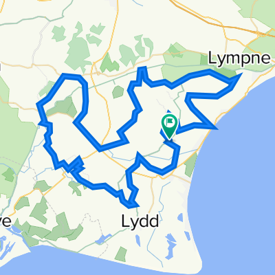
Route to Ham Street Station
A cycling route starting in Romney Marsh, England, United Kingdom.
Overview
About this route
0
- 53 min
- Duration
- 13 km
- Distance
- 24 m
- Ascent
- 26 m
- Descent
- 14.7 km/h
- Avg. speed
- 28 m
- Max. altitude
Teddy
created this 1 month ago
Route quality
Waytypes & surfaces along the route
Waytypes
Quiet road
8 km
62 %
Track
3.1 km
24 %
Surfaces
Paved
4.2 km
(32 %)
Asphalt
4.2 km
32 %
Undefined
8.8 km
68 %
Continue with Bikemap
Use, edit, or download this cycling route
You would like to ride Route to Ham Street Station or customize it for your own trip? Here is what you can do with this Bikemap route:
Free features
- Save this route as favorite or in collections
- Copy & plan your own version of this route
- Sync your route with Garmin or Wahoo
Premium features
Free trial for 3 days, or one-time payment. More about Bikemap Premium.
- Navigate this route on iOS & Android
- Export a GPX / KML file of this route
- Create your custom printout (try it for free)
- Download this route for offline navigation
Discover more Premium features.
Get Bikemap PremiumFrom our community
Other popular routes starting in Romney Marsh

 Channel 100/50 Challenge Ride - Channel 100/50 Challenge Ride0
- 78.4 km
- 80 m
- 82 m
- Romney Marsh, England, United Kingdom
 Pickneybush Lane, St. Mary In The Marsh, Romney Marsh to Cap Gris Nez, Hilders Cliff, Rye1
- 25.4 km
- 3 m
- 3 m
- Romney Marsh, England, United Kingdom


Open it in the app