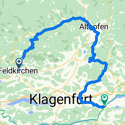
Feldkirchen - Markstein - Sittich - Briefelsdorf - Hart - St.Martin - Förolach - St.Ruprecht - Feld
A cycling route starting in Feldkirchen in Kärnten, Carinthia, Austria.
Overview
About this route
- -:--
- Duration
- 21 km
- Distance
- 415 m
- Ascent
- 365 m
- Descent
- ---
- Avg. speed
- 659 m
- Avg. speed
Route quality
Waytypes & surfaces along the route
Waytypes
Quiet road
13 km
(62 %)
Busy road
4 km
(19 %)
Surfaces
Paved
0.9 km
(4 %)
Unpaved
0.1 km
(<1 %)
Asphalt
0.6 km
(3 %)
Paved (undefined)
0.3 km
(1 %)
Continue with Bikemap
Use, edit, or download this cycling route
You would like to ride Feldkirchen - Markstein - Sittich - Briefelsdorf - Hart - St.Martin - Förolach - St.Ruprecht - Feld or customize it for your own trip? Here is what you can do with this Bikemap route:
Free features
- Save this route as favorite or in collections
- Copy & plan your own version of this route
- Sync your route with Garmin or Wahoo
Premium features
Free trial for 3 days, or one-time payment. More about Bikemap Premium.
- Navigate this route on iOS & Android
- Export a GPX / KML file of this route
- Create your custom printout (try it for free)
- Download this route for offline navigation
Discover more Premium features.
Get Bikemap PremiumFrom our community
Other popular routes starting in Feldkirchen in Kärnten
- Steinbichltour
- Distance
- 54.2 km
- Ascent
- 939 m
- Descent
- 939 m
- Location
- Feldkirchen in Kärnten, Carinthia, Austria
- RR-Berg: HA-Steuerberg-Köttern-Zedlitzberg-Himmelberg-Tiffen-Steindorf-Klachl-FE-HA
- Distance
- 43.5 km
- Ascent
- 621 m
- Descent
- 618 m
- Location
- Feldkirchen in Kärnten, Carinthia, Austria
- MTB-Flach: FE - Villach
- Distance
- 27.6 km
- Ascent
- 154 m
- Descent
- 202 m
- Location
- Feldkirchen in Kärnten, Carinthia, Austria
- GRV-Flach: HA-FE-Ossiach-Treffen-Krastal-Drautal-Lendorf
- Distance
- 72.3 km
- Ascent
- 686 m
- Descent
- 713 m
- Location
- Feldkirchen in Kärnten, Carinthia, Austria
- Sonnenuntergangsrunde
- Distance
- 20.4 km
- Ascent
- 175 m
- Descent
- 178 m
- Location
- Feldkirchen in Kärnten, Carinthia, Austria
- Feldkirchen - Himmelberg - Wachsenberg - Goggausee - Feldkirchen
- Distance
- 38.5 km
- Ascent
- 608 m
- Descent
- 607 m
- Location
- Feldkirchen in Kärnten, Carinthia, Austria
- RR-Berg: HA-FE-Himmelberg-Patergassen-BKK-Radenthein-Feld am See-Einöde-Treffen-Ossiach-Buchscheiden-FE-HA
- Distance
- 86 km
- Ascent
- 742 m
- Descent
- 742 m
- Location
- Feldkirchen in Kärnten, Carinthia, Austria
- Hügelige Runde Feldkirchen - Forstsee - Wernberg - Feldkirchen
- Distance
- 70.7 km
- Ascent
- 650 m
- Descent
- 650 m
- Location
- Feldkirchen in Kärnten, Carinthia, Austria
Open it in the app