

Sightseeing: Lage-BS-Kirchheide-Vlotho-Kalletal-Hollenstein
A cycling route starting in Lage, North Rhine-Westphalia, Germany.
Overview
About this route
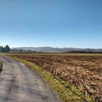
Very beautiful route for an afternoon outing.
The climbs to Kirchheide and Röntorf are quite challenging. However, afterward you can relax a bit towards Vlotho. A gentle but noticeable ascent then stretches all the way to Kalletal.
You can definitely treat yourself to a break at the ice cream shop there (affordable prices and a fun contest).
After that, you have to push yourself once more. The climb/serpentines to Talle are not easy, and the same goes for the final "long misery" from Kirchheide to Hollenstein.
Afterwards, you just have to somehow make it home;)
- -:--
- Duration
- 70 km
- Distance
- 620 m
- Ascent
- 593 m
- Descent
- ---
- Avg. speed
- 311 m
- Max. altitude

Route quality
Waytypes & surfaces along the route
Waytypes
Quiet road
14.7 km
(21 %)
Path
11.2 km
(16 %)
Surfaces
Paved
61.6 km
(88 %)
Unpaved
0.7 km
(1 %)
Asphalt
59.5 km
(85 %)
Paved (undefined)
2.1 km
(3 %)
Route highlights
Points of interest along the route
Point of interest after 42.5 km
Eisdiele Picoli, günstig und lecker;)

Point of interest after 52.7 km
Point of interest after 52.7 km

Point of interest after 56.2 km
Continue with Bikemap
Use, edit, or download this cycling route
You would like to ride Sightseeing: Lage-BS-Kirchheide-Vlotho-Kalletal-Hollenstein or customize it for your own trip? Here is what you can do with this Bikemap route:
Free features
- Save this route as favorite or in collections
- Copy & plan your own version of this route
- Sync your route with Garmin or Wahoo
Premium features
Free trial for 3 days, or one-time payment. More about Bikemap Premium.
- Navigate this route on iOS & Android
- Export a GPX / KML file of this route
- Create your custom printout (try it for free)
- Download this route for offline navigation
Discover more Premium features.
Get Bikemap PremiumFrom our community
Other popular routes starting in Lage
 Sightseeing: Lage-BS-Kirchheide-Vlotho-Kalletal-Hollenstein
- Distance
- 70 km
- Ascent
- 620 m
- Descent
- 593 m
- Location
- Lage, North Rhine-Westphalia, Germany
 Lage Hermannsdenkmal
- Distance
- 28.7 km
- Ascent
- 386 m
- Descent
- 385 m
- Location
- Lage, North Rhine-Westphalia, Germany
 zu den Externsteinen
- Distance
- 43.8 km
- Ascent
- 243 m
- Descent
- 243 m
- Location
- Lage, North Rhine-Westphalia, Germany
 OWL Lippe: Hermann-Gauseköte-Oerlinghausen
- Distance
- 89.9 km
- Ascent
- 676 m
- Descent
- 676 m
- Location
- Lage, North Rhine-Westphalia, Germany
 Sonntagmorgen Rundtour zum Skypoint Detmold und zurück.
- Distance
- 25.8 km
- Ascent
- 114 m
- Descent
- 113 m
- Location
- Lage, North Rhine-Westphalia, Germany
 Segelflugplatz und Wasserpark
- Distance
- 44 km
- Ascent
- 271 m
- Descent
- 270 m
- Location
- Lage, North Rhine-Westphalia, Germany
 Von Lage zur Stadthalle in Bielefeld und über Bad Salzuflen zurück
- Distance
- 54.4 km
- Ascent
- 191 m
- Descent
- 193 m
- Location
- Lage, North Rhine-Westphalia, Germany
 OWL Lippe: Hermann-Gauseköte-Oerlinghausen
- Distance
- 87.1 km
- Ascent
- 772 m
- Descent
- 772 m
- Location
- Lage, North Rhine-Westphalia, Germany
Open it in the app